
Google Maps API3 之 Hello World
<html xmlns="http://www.w3.org/1999/xhtml">
<head>
<meta http-equiv="Content-Type" content="text/html; charset=UTF-8" />
<title>My first map</title>
<style type="text/css">
<!-- #map
{
width:
100%;
height:
500px;
border:
1px
solid
#000;
}
-->
</style>
<script type="text/javascript" src="http://maps.google.com/maps/api/js?sensor=false"></script>
<script>
window.onload = function() {
// Creating a reference to the mapDiv
var mapDiv = document.getElementById('map');
// Creating a latLng for the center of the map
var latlng = new google.maps.LatLng(39.92, 116.46);
// Creating an object literal containing the properties
// we want to pass to the map
var options = {
center: latlng,
zoom: 10,
mapTypeId: google.maps.MapTypeId.ROADMAP
};
// Creating the map
var map = new google.maps.Map(mapDiv, options);
}
</script>
</head>
<body>
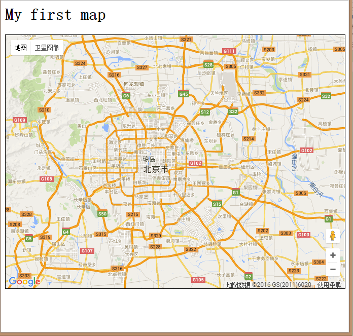
<h1>My first map</h1>
<div id="map"></div>
</body>
</html>
Google Maps API3 之 Hello World的更多相关文章
- 检索Google Maps地图位置(小训练)
名称:检索地图位置 内容:地图初期显示和检索显示 功能:根据条件检索地图的经度与纬度 1.在这之前我们需要创建一个表(Accoun__c),添加一个重要的字段地理位置情報,它会默认的给你两个字段经度和 ...
- Google Maps API V3 之绘图库 信息窗口
Google官方教程: Google 地图 API V3 使用入门 Google 地图 API V3 针对移动设备进行开发 Google 地图 API V3 之事件 Google 地图 API V3 ...
- Google Maps API V3 之 图层
Google官方教程: Google 地图 API V3 使用入门 Google 地图 API V3 针对移动设备进行开发 Google 地图 API V3 之事件 Google 地图 API V3 ...
- Google Maps API V3 之 路线服务
Google官方教程: Google 地图 API V3 使用入门 Google 地图 API V3 针对移动设备进行开发 Google 地图 API V3 之事件 Google 地图 API V3 ...
- Google Maps地图投影全解析(3):WKT形式表示
update20090601:EPSG对该投影的编号设定为EPSG:3857,对应的WKT也发生了变化,下文不再修改,相对来说格式都是那样,可以到http://www.epsg-registry.or ...
- google maps js v3 api教程(3) -- 创建infowindow
原文地址 前面我们学习了地图和标记的创建.那么今天我们来学习怎样在地图上显示一个窗口(infowindow) infowindow构造函数为:InfoWindow(opts?:InfoWindowOp ...
- google maps js v3 api教程(2) -- 在地图上添加标记
原文链接 google maps javascript官方文档:https://developers.google.com/maps/documentation/javascript/ 我们在创建地图 ...
- google maps js v3 api教程(1) -- 创建一个地图
原文地址 google maps javascript官方文档:https://developers.google.com/maps/documentation/javascript/ 在创建地图之前 ...
- Google Maps投影在ArcGIS中的设置
Google Maps采用的地图投影为Web Mercator,其优点为不同维度其形状保持不变,当然面积要发生变化. ArcGIS9.3中可以直接设置为WGS 1984 Web Mercator,操作 ...
随机推荐
- sysconf获取系统参数
头文件: #include <unistd.h> 原型:long sysconf(int sysnum); 示例: #include <stdio.h> #include &l ...
- [转帖]Docker 更新版本 以及 data-root
Docker 更新版本 https://www.cnblogs.com/operationhome/archive/2019/08/11/11322150.html 园友说 docker 使用了 da ...
- H3C 交换机配置ssh登陆
1.开启ssh服务,创建密钥. <D05-S5048-02>system-view [D05-S5048-02]ssh server enable //开启ssh服务 [D05-S5048 ...
- 使用 Mybatis-plus 进行 crud 操作
1 Mybatis-Plus简介 1.1 什么是Mybatis-Plus MyBatis-Plus(简称 MP)是一个 MyBatis 的增强工具,在 MyBatis 的基础上只做增强不做改变,为简化 ...
- spring-redis使用
导包 注入调用 opsForValue() opsForList() redisTemplate 配置 ,为了 对key采用string序列化方式 ...
- J.U.C之AQS介绍
从JDK1.5开始,引入了并发包java.util.concurrent(J.U.C),并发容器里的同步容器AQS(AbstractQueuedSynchronizer)是J.U.C的核心,AQS底层 ...
- Thinking In Java 4th Chap2 一切都是对象
对基本数据类型的初始化有二: 1.String s="asdf"; 2.String s=new String("asdf"); 可能的存储区域: 寄存器(不可 ...
- Synchronized&Lock&AQS详解
加锁目的:由于线程执行的过程是不可控的,所以需要采用同步机制来协同对对象可变状态的访问. 加锁方式:java锁分为两种--显示锁和隐示锁,本质区别在于显示锁需要的是程序员自己手动的进行加锁与解锁如Re ...
- oracle基本查询01
/*数据库-----> 数据库实例----->表空间[逻辑单位]------>数据文件[物理单位] 通常情况下oracle数据库只会有一个实例ORCL 新建一个项目: MYSQL:创 ...
- sqlce基本语法
整理和总结一下SQLCE的用法引用 System.Data.SqlServerCe(1)数据库文件的创建 SqlCeEngine eng = new SqlCeEngine("Da ...