openlayers5-webpack 入门开发系列结合 turf.js 实现等值线(附源码下载)
前言
openlayers5-webpack 入门开发系列环境知识点了解:
- node 安装包下载
webpack 打包管理工具需要依赖 node 环境,所以 node 安装包必须安装,上面链接是官网下载地址- webpack 配置介绍文档
详细的 webpack 文档配置介绍,适合新手查看,我也是边看边学- vscode 安装包下载,我这边用 vscode工具编译开发前端项目,个人觉的这款工具还不错
- openlayers5 api文档介绍,详细介绍 openlayers5 每个类的函数以及属性等等
- openlayers5 在线例子
内容概览
openlayers5 结合 turf.js 实现等值线
源代码 demo 下载
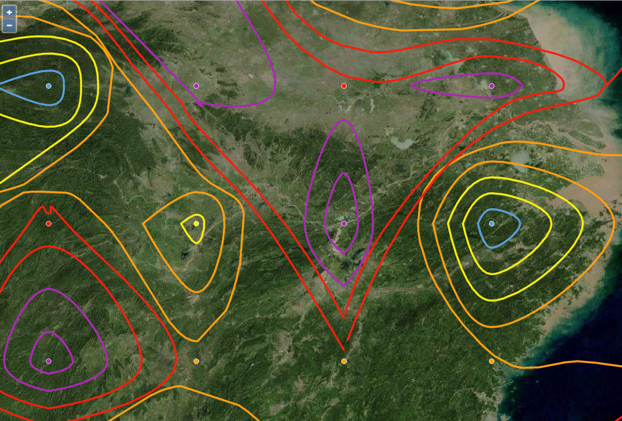
效果图如下: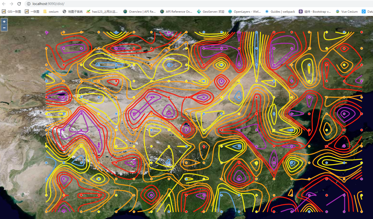
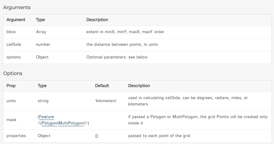
- 关键函数 turf.pointGrid,从边界框,FeatureCollection 或 Feature创建点网格
- 关键函数turf.isolines,采用具有z值和值中断数的 Point 要素的网格 FeatureCollection 并生成等值线
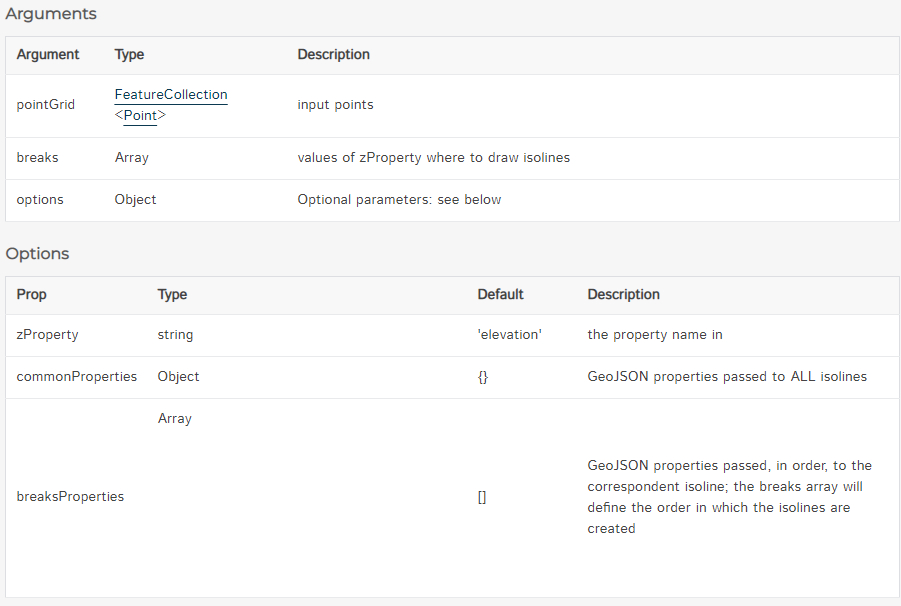
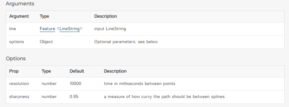
- 关键函数 turf.bezierSpline,通过应用 Bezier 样条算法获取一条线并返回弯曲版本
- 核心代码如下:
import {Map, View} from 'ol';

import TileLayer from 'ol/layer/Tile';

import XYZ from 'ol/source/XYZ';

import 'ol/ol.css';

import Style from 'ol/style/Style';

import Fill from 'ol/style/Fill';

import Stroke from 'ol/style/Stroke';

import CircleStyle from 'ol/style/Circle';

import GeoJSON from 'ol/format/GeoJSON';

import VectorSource from 'ol/source/Vector';

import VectorLayer from 'ol/layer/Vector';

import * as turf from "@turf/turf";

/*

*根据要素feature动态渲染样式符号

*/

function styleFunction(feature) {

var tem = feature.get("temperature");//获取属性temperature值

var colors = ["#5a9fdd", "#f7eb0c", "#fc9e10", "#f81e0d", "#aa2ab3"];//定义颜色分组

var color = colors[parseInt(tem/2)];//根据属性值来计算对应的颜色值

return new Style({

fill: new Fill({

color: color

}),

stroke: new Stroke({

color: color,

width: 4

}),

image: new CircleStyle({

radius: 5,

fill: new Fill({

color: color

}),

stroke: new Stroke({

color: '#fff',

width: 1

})

})

});

}

var extent = [72.8613, 20.0559, 133.9453, 54.5721];//网格点插值范围经纬度

var cellWidth = 3;//等距点,单位为经纬度

var pointGrid = turf.pointGrid(extent, cellWidth, {units: 'degrees'});//创建等距点的网格,单位为经纬度

for (var i = 0; i < pointGrid.features.length; i++) {

pointGrid.features[i].properties.temperature = Math.random() * 10;//随机0-10之间随机赋值温度属性值temperature

}
……
完整demo源码见小专栏文章尾部:GIS之家openlayers小专栏
文章尾部提供源代码下载,对本专栏感兴趣的话,可以关注一波
openlayers5-webpack 入门开发系列结合 turf.js 实现等值线(附源码下载)的更多相关文章
- openlayers4 入门开发系列结合 echarts4 实现散点图(附源码下载)
前言 openlayers4 官网的 api 文档介绍地址 openlayers4 api,里面详细的介绍 openlayers4 各个类的介绍,还有就是在线例子:openlayers4 官网在线例子 ...
- leaflet-webpack 入门开发系列三地图分屏对比(附源码下载)
前言 leaflet-webpack 入门开发系列环境知识点了解: node 安装包下载webpack 打包管理工具需要依赖 node 环境,所以 node 安装包必须安装,上面链接是官网下载地址 w ...
- cesium 入门开发系列矢量瓦片加载展示(附源码下载)
前言 cesium 入门开发系列环境知识点了解:cesium api文档介绍,详细介绍 cesium 每个类的函数以及属性等等cesium 在线例子 内容概览 cesium 实现矢量瓦片加载效果 源代 ...
- openlayers4 入门开发系列之地图展示篇(附源码下载)
前言 openlayers4 官网的 api 文档介绍地址 openlayers4 api,里面详细的介绍 openlayers4 各个类的介绍,还有就是在线例子:openlayers4 官网在线例子 ...
- openlayers4 入门开发系列之聚合图篇(附源码下载)
前言 openlayers4 官网的 api 文档介绍地址 openlayers4 api,里面详细的介绍 openlayers4 各个类的介绍,还有就是在线例子:openlayers4 官网在线例子 ...
- openlayers4 入门开发系列之迁徙图篇(附源码下载)
前言 openlayers4 官网的 api 文档介绍地址 openlayers4 api,里面详细的介绍 openlayers4 各个类的介绍,还有就是在线例子:openlayers4 官网在线例子 ...
- openlayers4 入门开发系列之地图工具栏篇(附源码下载)
前言 openlayers4 官网的 api 文档介绍地址 openlayers4 api,里面详细的介绍 openlayers4 各个类的介绍,还有就是在线例子:openlayers4 官网在线例子 ...
- openlayers4 入门开发系列之地图切换篇(附源码下载)
前言 openlayers4 官网的 api 文档介绍地址 openlayers4 api,里面详细的介绍 openlayers4 各个类的介绍,还有就是在线例子:openlayers4 官网在线例子 ...
- arcgis api 3.x for js 入门开发系列十三地图最短路径分析(附源码下载)
前言 关于本篇功能实现用到的 api 涉及类看不懂的,请参照 esri 官网的 arcgis api 3.x for js:esri 官网 api,里面详细的介绍 arcgis api 3.x 各个类 ...
- arcgis api 3.x for js 入门开发系列十叠加 SHP 图层(附源码下载)
前言 关于本篇功能实现用到的 api 涉及类看不懂的,请参照 esri 官网的 arcgis api 3.x for js:esri 官网 api,里面详细的介绍 arcgis api 3.x 各个类 ...
随机推荐
- 类型擦除真的能完全擦除一切信息吗?java 泛型揭秘
背景 我们都知道泛型本质上是提供类型的"类型参数",它们也被称为参数化类型(parameterized type)或参量多态(parametric polymorphism).其实 ...
- oracle基础(基本介绍)
数据库 磁盘上存储的数据的集合 在物理上表现为数据文件.日志文件和控制文件等 在逻辑上以表空间形式存在 必须首先创建数据库,然后才能使用Oracle 数据库实例 每个启动的数据库都对应一个数据库实例, ...
- python的模块future用法实例解析
计算机的知识太多了,很多东西就是一个使用过程中详细积累的过程.最近遇到了一个很久关于future的问题,踩了坑,这里就做个笔记,免得后续再犯类似错误. future的作用:把下一个新版本的特性导入 ...
- 理解Spark SQL(二)—— SQLContext和HiveContext
使用Spark SQL,除了使用之前介绍的方法,实际上还可以使用SQLContext或者HiveContext通过编程的方式实现.前者支持SQL语法解析器(SQL-92语法),后者支持SQL语法解析器 ...
- SQLite性能 - 意想不到,但又情理之中的测试结果。
win7(64) sata2 希捷 MINGW32_NT-(/) cat: /proc/cpuinfo: No such file or directory ------ in disk ---- r ...
- opencv 7 直方图与匹配
图像直方图概述 直方图的计算与绘制 计算直方图:calcHist()函数 找寻最值:minMaxLoc()函数 示例程序:绘制H-S直方图 #include "opencv2/highgui ...
- vue3.0里的生命周期函数
- 最省钱的爬虫解决方案,比IP代理更划算
现状: 1.网上提供代理IP池的解决方案非常多,价格也有高有低,包天/月/年的都有,品质都要靠自己去尝试. 2.试过之后,发现成本相对高,每月要花200~300元, 所以希望研究一下是否有更性价比高的 ...
- day20191012笔记
课程默写笔记: 1.程序架构 C/S 客户端/服务器端 B/S 浏览器/服务器端 2.Tomcat应用服务器 tomcat默认端口号是80:tomcat配置文件中通常端口的定义是8080: 3.使用开 ...
- css之文本两端对齐的两种解决方法
说起文本对齐,大家都知道text-align,最常用的有left.right.center,今天我们说一下justify,也就是文本两端 对齐.说起来简单,但是有些小坑大家还是要注意的. 现在我们有这 ...