echart 插件实现全国地图
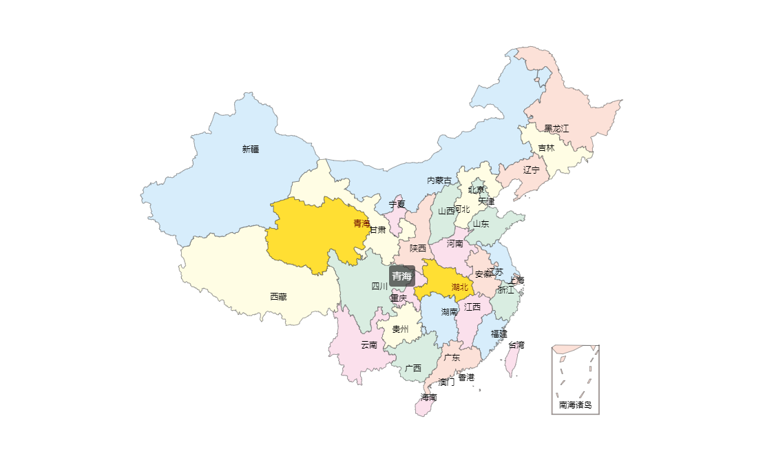
最近的项目要用到一个能展现全国地图的功能,并且全国各个省份显示的颜色不同,点击省份后会返回省份名称。经过反复的查找最终确定了echart这个插件,最后的成果还不错,在这里写下来希望对大家有所帮助。话不多说先看最终的效果图。

最终的效果就是这个样子的啦,感觉还是很好看的,echart这个插件使用还是很简单的,按照官网步骤来就好了。官网地址:http://echarts.baidu.com/index.html
下面就是我实现这个效果的代码了:
<!DOCTYPE html>
<html style="height: 100%"> <head>
<meta charset="utf-8">
</head> <body style="height: 100%; margin: 0">
<div id="container" style="height: 100%"></div>
<script type="text/javascript" src="js/echarts.min.js"></script> <script type="text/javascript" src="http://echarts.baidu.com/gallery/vendors/echarts/map/js/china.js"></script> <script type="text/javascript">
var myChart = echarts.init(document.getElementById("container")); option = { tooltip: {
trigger: 'item',
formatter: '{b}'
}, series: [{
name: '中国',
type: 'map',
mapType: 'china',
selectedMode: 'single',
roam: false,
label: {
normal: {
show: true
},
emphasis: {
show: true
}
},
data: [{
name: '北京',
itemStyle: {
normal: {
areaColor: '#D9EDE1'
}
}
},
{
name: '天津',
itemStyle: {
normal: {
areaColor: '#D9EDE1'
}
}
},
{
name: '上海',
itemStyle: {
normal: {
areaColor: '#FCE1D8'
}
}
},
{
name: '重庆',
itemStyle: {
normal: {
areaColor: '#FBE0EC'
}
}
},
{
name: '河北',
itemStyle: {
normal: {
areaColor: '#FFFDE4'
}
}
},
{
name: '河南',
itemStyle: {
normal: {
areaColor: '#FBE0EC'
}
}
},
{ name: '云南',
itemStyle: {
normal: {
areaColor: '#FBE0EC'
}
}
},
{
name: '辽宁',
itemStyle: {
normal: {
areaColor: '#FCE1D8'
}
}
},
{
name: '黑龙江',
itemStyle: {
normal: {
areaColor: '#FCE1D8'
}
}
},
{
name: '湖南',
itemStyle: {
normal: {
areaColor: '#D7EDFB'
}
}
},
{
name: '安徽',
itemStyle: {
normal: {
areaColor: '#FCE1D8'
}
}
},
{
name: '山东',
itemStyle: {
normal: {
areaColor: '#D9EDE1'
}
}
},
{
name: '新疆',
itemStyle: {
normal: {
areaColor: '#D7EDFB'
}
}
},
{
name: '江苏',
itemStyle: {
normal: {
areaColor: '#D7EDFB'
}
}
},
{
name: '浙江',
itemStyle: {
normal: {
areaColor: '#D9EDE1'
}
}
},
{
name: '江西',
itemStyle: {
normal: {
areaColor: '#FBE0EC'
}
}
},
{
name: '湖北',
itemStyle: {
normal: {
areaColor: '#FFFDE4'
}
},
selected: true
},
{
name: '广西',
itemStyle: {
normal: {
areaColor: '#D9EDE1'
}
}
},
{
name: '甘肃',
itemStyle: {
normal: {
areaColor: '#FFFDE4'
}
}
},
{
name: '山西',
itemStyle: {
normal: {
areaColor: '#D9EDE1'
}
}
},
{
name: '内蒙古',
itemStyle: {
normal: {
areaColor: '#D7EDFB'
}
}
},
{
name: '陕西',
itemStyle: {
normal: {
areaColor: '#FCE1D8'
}
}
},
{
name: '吉林',
itemStyle: {
normal: {
areaColor: '#FFFDE4'
}
}
},
{
name: '福建',
itemStyle: {
normal: {
areaColor: '#D7EDFB'
}
}
},
{
name: '贵州',
itemStyle: {
normal: {
areaColor: '#FFFDE4'
}
}
},
{
name: '广东',
itemStyle: {
normal: {
areaColor: '#FCE1D8'
}
}
},
{
name: '青海',
itemStyle: {
normal: {
areaColor: '#FBE0EC'
}
}
},
{
name: '西藏',
itemStyle: {
normal: {
areaColor: '#FFFDE4'
}
}
},
{
name: '四川',
itemStyle: {
normal: {
areaColor: '#D9EDE1'
}
}
},
{
name: '宁夏',
itemStyle: {
normal: {
areaColor: '#FBE0EC'
}
}
},
{
name: '海南',
itemStyle: {
normal: {
areaColor: '#FBE0EC'
}
}
},
{
name: '台湾',
itemStyle: {
normal: {
areaColor: '#FBE0EC'
}
}
},
{
name: '香港',
itemStyle: {
normal: {
areaColor: '#FCE1D8'
}
}
},
{
name: '澳门',
itemStyle: {
normal: {
areaColor: '#FCE1D8'
}
}
},
{
name: '南海诸岛',
itemStyle: {
normal: {
areaColor: '#FCE1D8'
}
}
}
]
}]
}; myChart.setOption(option, true);
</script>
</body> </html>
这部分代码只引用了一个js文件,这个官网就可以下载的到,最后还有两个细节的部分提醒大家:
1.点击省份返回省份信息
 myChart.on('click', function(params) {

             console.log(params.name);

 });
只要有这部分代码就可以实现点击省份返回省份名称的功能啦!
2.关于地图的大小问题
尽管地图的大小和echart的容器大小挂钩,但是地图在容器内并不是全部占满的,这样就会影响一部分的美观,解决这个问题。只要添加一个属性就可以 了。
     series: [{

                     name: '中国',

                     type: 'map',

                     mapType: 'china',

                     selectedMode: 'single',

                     roam: false,

                 zoom: 1.2,

                     label: {

                         normal: {

                             show: true

                         },

                         emphasis: {

                             show: true

                         }

                     },

             ...}]
注意 zoom: 1.2 这个属性是让地图放大的关键,看一下效果对比图
放大前:
放大地图后:
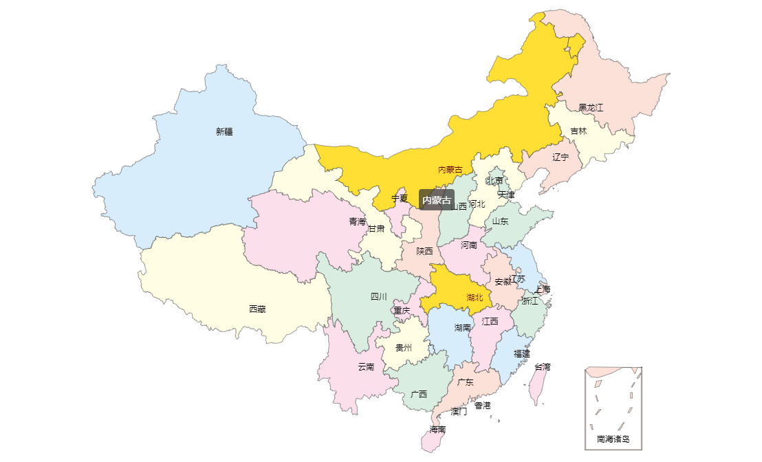
在容器大小一致的情况下,地图明显变大了。
好了,这就是我在项目中遇到的一个小小的问题,已经解决了,也希望对大家有所帮助,大家如果有更好的实现方式也欢迎在评论中提出。
echart 插件实现全国地图的更多相关文章
- MVC中使用Echart后台加载数据 实现饼图、折线图、全国地图数据,单击双击事件等
@{ Layout = null; } @if (false) { <script src="~/Js/jquery-easyui-1.5/jquery.min.js"> ...
- arcgis for flex全国地图天气预报的具体实现过程解析
系统架构是B/S,开发语言是flex,开发工具是myeclise或者flashbuild,通过调用百度提供的在线天气预报web api接口的方式来实现. 采用地图是ArcGIS全国地图,开发接口为ar ...
- arcgis for flex或silverlight全国地图天气预报的实现
系统架构是B/S,目前有两个不同的版本,1.开发语言是C#.silverlight,开发平台是.NET:2.开发语言是java.flex,开发平台是myeclise. 采用地图是ArcGIS全国地图, ...
- vue+echarts可视化大屏,全国地图下钻,页面自适应
之前写过一篇关于数据大屏及地图下钻的文章 https://www.cnblogs.com/weijiutao/p/13977011.html ,但是存在诸多问题,如地图边界线及行政区划老旧,无法自适应 ...
- 使用JS+Three.js+Echart开发商场室内地图客流信息统计功能
现在的商场管理者在管理商场的同时面临着一些无法避免的问题比如:人员监管不到位.效率低下.商场同质化严重,人流量少等.发现了这些问题作为开发人员的我们怎能视而不见,我们的责任就是发现问题解决问题,提供更 ...
- 线形,柱形,条形数据表(百度Echart插件)
[获取资源]进入官网, http://echarts.baidu.com/导航,下载,下拉框下载,常用303k.就是这么简单,就个一个js.[项目使用]新建项目,MyChart具体使用的过程中, ...
- 百度地图插件(百度地图AK申请配置指南)
百度地图AK申请配置指南 [LBS云] 百度地图AK申请配置指南 1. 该文档是详细版,图文并茂: 2. 该指南是针对browser-mobile-sever三种终端开发的申请与配置说明: 3 ...
- ionic3使用echart插件
安装 看官方文档可以知道ECharts可以在webpack中使用看这里,故我们可以使用npm下载安装到项目中 npm install echarts --save //下载ECharts npm in ...
- 通过百度地图API--获取全国地图的经纬度
因为要做一个前端画图需要经纬度,一个个的查询过麻烦,最终弄出这个,以备后查! import threading , time import requests from decimal import D ...
随机推荐
- springboot mybatis 后台框架平台 shiro 权限 集成代码生成器
1.代码生成器: [正反双向](单表.主表.明细表.树形表,快速开发利器)+快速表单构建器freemaker模版技术 ,0个代码不用写,生成完整的一个模块,带页面.建表sql脚本.处理类.servic ...
- Lucene-----信息检索技术
1 信息检索概述 1.1 传统检索方式的缺点 • 文件检索 操作系统常见的是硬盘文件检索 文档检索:整个文档打开时已经加载到内存了; 缺点:全盘遍历, ...
- JavaScript总结(二)
JavaScript的数据类型 ✍ 原始数据类型值: JavaScript有5中原始数据类型,通过调用typeof运算符返回值查看变量类型: ➣ Undefined ➔ 'undefined': Un ...
- 【python3】爬取鼠绘汉化的海贼王漫画
特别说明: 因为早些时候鼠绘的接口调整,之前的代码已经不能用了. 正好最近在学习scrapy,于是重新写了一个,项目放在github https://github.com/TurboWay/ishu ...
- 24-[jQuery]-案例
1.仿淘宝导航栏案例 <!DOCTYPE html> <html lang="en"> <head> <meta charset=&quo ...
- 菜鸟vimer成长记——第2.1章、normal模式
目的 掌握normal模式下常用操作的语法和概念,这些操作对应的应用场景以及实用技巧. 通过normal模式举一反三掌握cmd-line和visual的常用文本操作. 简介 文本操作的理想状态为:一个 ...
- .net mvc中session的锁机制
今天遇到个奇怪的问题, 一个秒杀商品系统, 大量秒杀请求进来, 到了action居然是单线程执行! 这样产生的效果就是“这个系统好慢啊!!”. 可是我没有加lock,为什么会变成单线程执行呢? 找资料 ...
- 解决在控制层springmvc框架发出的400状态的错误
错误场景: 错误分析: 这也是我第一次遇到这个类型的异常,400响应状态代表:客户端发出的请求中携带的参数与服务器端接受的参数类型不匹配,进一步就是说我后台的实体类中数据类型为Date,而前台传递过来 ...
- 我的第一个bootstrap实例
先上代码: <!doctype html><html lang="en"><head> <meta charset="UTF-8 ...
- SICP读书笔记 3.3
SICP CONCLUSION 让我们举起杯,祝福那些将他们的思想镶嵌在重重括号之间的Lisp程序员 ! 祝我能够突破层层代码,找到住在里计算机的神灵! 目录 1. 构造过程抽象 2. 构造数据抽象 ...