
ArcGIS for Android 地图图文查询
ArcGIS for Android 地图图文查询
1.前期项目准备
1.1. 创建新工程
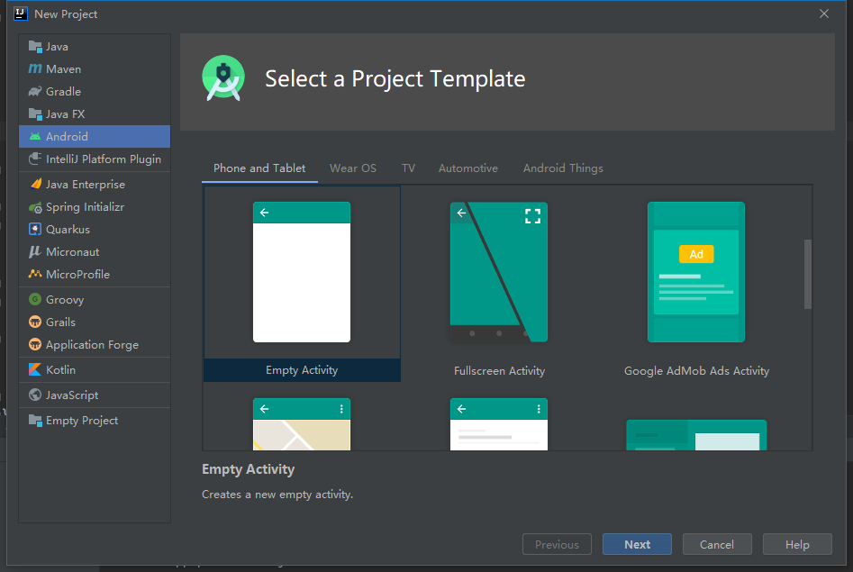
新建一个空活动项目
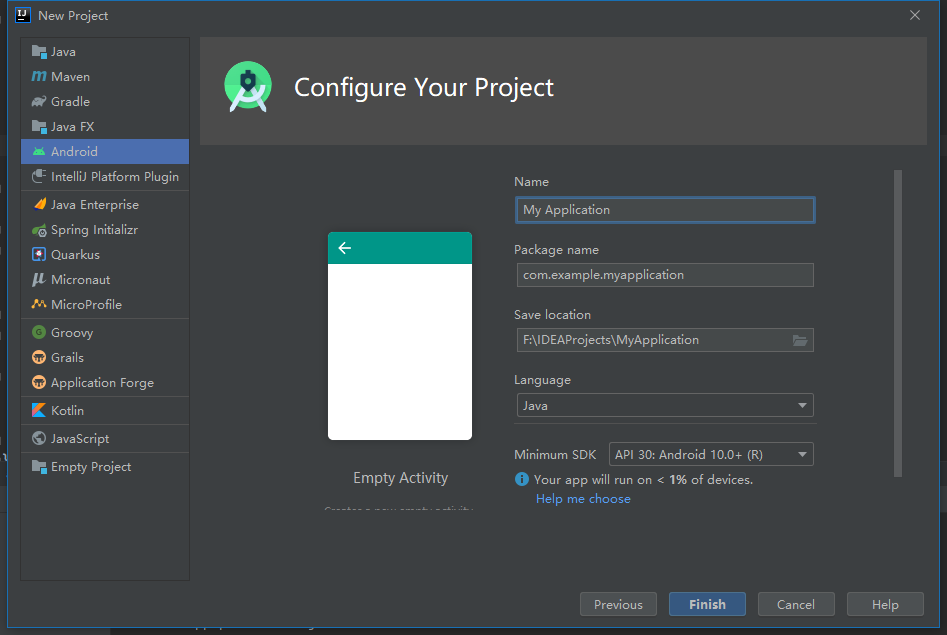
选择语言、平台,修改命名等
1.2. 添加ArcGIS SDK
build.gradle (Project: <project name>)添加maven {
url 'https://esri.jfrog.io/artifactory/arcgis'
}
build.gradle (Module: <module name>)添加implementation 'com.esri.arcgisruntime:arcgis-android:100.10.0'
Gradle更新:Sync Project with Gradle FilesAndroidManifest.xml添加//网络权限
<uses-permission android:name="android.permission.INTERNET" />
//use a MapView (2D) require at least OpenGL ES 2.x:
<uses-feature android:glEsVersion="0x00020000" android:required="true" />
在
appdbuild.gradle(Module:app)的android部分指定Java版本compileOptions {
sourceCompatibility JavaVersion.VERSION_1_8
targetCompatibility JavaVersion.VERSION_1_8
}
1.3. 添加MapView地图控件
修改
activity_main.xml,替换TextView<com.esri.arcgisruntime.mapping.view.MapView
android:id="@+id/mapView"
android:layout_height="fill_parent"
android:layout_width="fill_parent"
tools:ignore="MissingConstraints">
</com.esri.arcgisruntime.mapping.view.MapView>
2.地图点击查询属性
2.1.定义变量
定义相关变量
private MapView mMapView;
private Callout mCallout;
private ServiceFeatureTable mServiceFeatureTable;
2.2.添加在线图层
通过新建ServiceFeatureTable实例添加在线图层
mServiceFeatureTable =new ServiceFeatureTable(getResources().getString(R.string.us_daytime_population_url));
mFeatureLayer=new FeatureLayer(mServiceFeatureTable);
mFeatureLayer.setOpacity(0.8f);
mFeatureLayer.setMaxScale(10000);
SimpleLineSymbol lineSymbol=new SimpleLineSymbol(SimpleLineSymbol.Style.SOLID, Color.BLACK, 1);
SimpleFillSymbol fillSymbol=new SimpleFillSymbol(SimpleFillSymbol.Style.SOLID, Color.YELLOW, lineSymbol);
mFeatureLayer.setRenderer(new SimpleRenderer(fillSymbol));
map.getOperationalLayers().add(mFeatureLayer);
mMapView.setViewpointCenterAsync(new Point(-11000000,5000000, SpatialReferences.getWebMercator()),100000000);
mCallout=mMapView.getCallout();
2.3.添加点击(touch)监听
mMapView.setOnTouchListener(new DefaultMapViewOnTouchListener(this,mMapView){
@Override
public boolean onSingleTapConfirmed(MotionEvent e) {
if (mCallout.isShowing()){
mCallout.dismiss();
}
final android.graphics.Point screenPoint =new android.graphics.Point(Math.round(e.getX()),Math.round(e.getY()));
int tolerance = 10;
final ListenableFuture<IdentifyLayerResult> identifyLayerResultListenableFuture=
mMapView.identifyLayerAsync(mFeatureLayer,screenPoint,tolerance,false,1);
identifyLayerResultListenableFuture.addDoneListener(()->{
try {
IdentifyLayerResult identifyLayerResult=identifyLayerResultListenableFuture.get();
TextView calloutContent = new TextView(getApplicationContext());
calloutContent.setTextColor(Color.BLACK);
calloutContent.setSingleLine(false);
calloutContent.setVerticalScrollBarEnabled(true);
calloutContent.setScrollBarStyle(View.SCROLLBARS_INSIDE_INSET);
calloutContent.setMovementMethod(new ScrollingMovementMethod());
calloutContent.setLines(identifyLayerResult.getElements().get(0).getAttributes().size());
for (GeoElement element:identifyLayerResult.getElements()){
Feature feature =(Feature) element;
Map<String,Object> attr =feature.getAttributes();
Set<String> keys=attr.keySet();
for (String key:keys){
Object value =attr.get(key);
if (value instanceof GregorianCalendar){
SimpleDateFormat simpleDateFormat=new SimpleDateFormat("dd-MMM-yyyy", Locale.US);
value=simpleDateFormat.format(((GregorianCalendar) value).getTime());
}
calloutContent.append(key+" | "+value+"\n");
}
Envelope envelope=feature.getGeometry().getExtent();
mMapView.setViewpointGeometryAsync(envelope,10);
mCallout.setLocation(envelope.getCenter());
mCallout.setContent(calloutContent);
mCallout.show();
}
}catch (Exception e1){
Log.e(getResources().getString(R.string.app_name),"Select feature fail : "+e1.getMessage());
}
});
return super.onSingleTapConfirmed(e);
}
});
2.4.重写onPause()、onResume()、onDestroy()函数
@Override
protected void onPause() {
mMapView.pause();
super.onPause();
}
@Override
protected void onResume() {
super.onResume();
mMapView.resume();
}
@Override protected void onDestroy() {
mMapView.dispose();
super.onDestroy();
}
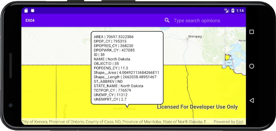
2.5.编译测试
3.输入属性查询地图对象
3.1.定义变量
定义相关变量
private MapView mMapView;
private ServiceFeatureTable mServiceFeatureTable;
private FeatureLayer mFeatureLayer;
3.2.添加在线图层
通过新建ServiceFeatureTable实例添加在线图层
mServiceFeatureTable =new ServiceFeatureTable(getResources().getString(R.string.us_daytime_population_url));
mFeatureLayer=new FeatureLayer(mServiceFeatureTable);
mFeatureLayer.setOpacity(0.8f);
mFeatureLayer.setMaxScale(10000);
SimpleLineSymbol lineSymbol=new SimpleLineSymbol(SimpleLineSymbol.Style.SOLID, Color.BLACK, 1);
SimpleFillSymbol fillSymbol=new SimpleFillSymbol(SimpleFillSymbol.Style.SOLID, Color.YELLOW, lineSymbol);
mFeatureLayer.setRenderer(new SimpleRenderer(fillSymbol));
map.getOperationalLayers().add(mFeatureLayer);
mMapView.setViewpointCenterAsync(new Point(-11000000,5000000, SpatialReferences.getWebMercator()),100000000);
3.3.添加搜索框
在res文件夹下添加searchable.xml
<?xml version="1.0" encoding="utf-8"?>
<searchable xmlns:android="http://schemas.android.com/apk/res/android"
android:label="@string/app_name"
android:hint="@string/search_hint" >
</searchable>
在menu文件夹下创建menu_main.xml
<menu xmlns:android="http://schemas.android.com/apk/res/android"
xmlns:app="http://schemas.android.com/apk/res-auto"
xmlns:tools="http://schemas.android.com/tools"
tools:context=".MainActivity">
<item
android:id="@+id/action_search"
android:title="@string/action_search"
app:actionViewClass="androidx.appcompat.widget.SearchView"
app:showAsAction="ifRoom" />
</menu>
在AndriodManifest.xml中的application中添加
<activity
android:name=".MainActivity"
android:label="@string/app_name"
android:launchMode="singleTop">
<intent-filter>
<action android:name="android.intent.action.MAIN" />
<category android:name="android.intent.category.LAUNCHER" />
</intent-filter>
<intent-filter>
<action android:name="android.intent.action.SEARCH" />
</intent-filter>
<meta-data
android:name="android.app.searchable"
android:resource="@xml/searchable" />
</activity>
3.4.重写onCreateOptionsMenu()函数
@Override
public boolean onCreateOptionsMenu(Menu menu) {
// inflate the menu; this adds items to the action bar if it is present.
getMenuInflater().inflate(R.menu.menu_main, menu);
// get the SearchView and set the searchable configuration
SearchManager searchManager = (SearchManager) getSystemService(Context.SEARCH_SERVICE);
SearchView searchView = (SearchView) menu.findItem(R.id.action_search).getActionView();
// assumes current activity is the searchable activity
searchView.setSearchableInfo(searchManager.getSearchableInfo(getComponentName()));
searchView.setIconifiedByDefault(false);
return true;
}
3.5.重写onNewIntent()函数
@Override
protected void onNewIntent(Intent intent) {
setIntent(intent);
if (Intent.ACTION_SEARCH.equals(intent.getAction())){
String searchString=intent.getStringExtra(SearchManager.QUERY);
searchForState(searchString);
}
}
private void searchForState(String searchString) {
mFeatureLayer.clearSelection();
QueryParameters query = new QueryParameters();
query.setWhereClause(searchString.toUpperCase());
final ListenableFuture<FeatureQueryResult> future = mServiceFeatureTable.queryFeaturesAsync(query);
future.addDoneListener(()->{
try {
FeatureQueryResult result=future.get();
Iterator<Feature> resultIterator=result.iterator();
int size=0;
for (int i=0;resultIterator.hasNext();i++){
Feature feature =resultIterator.next();
Envelope envelope=feature.getGeometry().getExtent();
mMapView.setViewpointGeometryAsync(envelope,10);
mFeatureLayer.selectFeature(feature);
size++;
}
if (size>0){
Toast.makeText(this,"Found : "+size+" record(s)",Toast.LENGTH_LONG).show();
} else {
Toast.makeText(this,"No states found with name: "+searchString,Toast.LENGTH_LONG).show();
}
}catch (Exception e){
String error = "Feature search failed for: " + searchString + ". Error: " + e.getMessage();
Toast.makeText(this, error, Toast.LENGTH_LONG).show();
Log.e("Search for states error :", error);
}
});
}
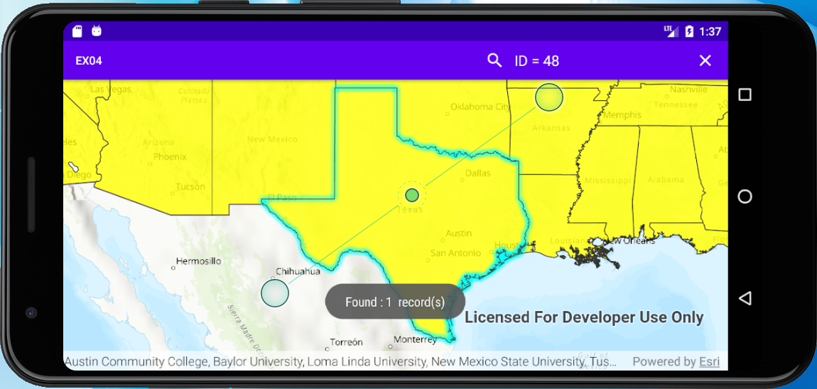
3.6.编译测试
4.完整代码
4.1.资源文件
strings.xml文件:
<resources>
<string name="app_name">EX04</string>
<string name="sample_service_url">https://sampleserver6.arcgisonline.com/arcgis/rest/services/Recreation/FeatureServer/0</string>
<string name="API_KEY">YOU_ArcGIS_API_KEY</string>
<string name="us_daytime_population_url">https://services.arcgis.com/jIL9msH9OI208GCb/arcgis/rest/services/USA_Daytime_Population_2016/FeatureServer/0</string>
<string name="action_search">Search</string>
<string name="search_hint">Type search opinions</string>
</resources>
searchable.xml文件:
<?xml version="1.0" encoding="utf-8"?>
<searchable xmlns:android="http://schemas.android.com/apk/res/android"
android:label="@string/app_name"
android:hint="@string/search_hint" >
</searchable>
menu_main.xml文件:
<menu xmlns:android="http://schemas.android.com/apk/res/android"
xmlns:app="http://schemas.android.com/apk/res-auto"
xmlns:tools="http://schemas.android.com/tools"
tools:context=".MainActivity">
<item
android:id="@+id/action_search"
android:title="@string/action_search"
app:actionViewClass="androidx.appcompat.widget.SearchView"
app:showAsAction="ifRoom" />
</menu>
activity_main.xml文件:
<?xml version="1.0" encoding="utf-8"?>
<androidx.constraintlayout.widget.ConstraintLayout
xmlns:android="http://schemas.android.com/apk/res/android"
xmlns:tools="http://schemas.android.com/tools"
xmlns:app="http://schemas.android.com/apk/res-auto"
android:layout_width="match_parent"
android:layout_height="match_parent"
tools:context=".MainActivity">
    <com.esri.arcgisruntime.mapping.view.MapView

            android:id="@+id/mapView"

            android:layout_height="fill_parent"

            android:layout_width="fill_parent"

            tools:ignore="MissingConstraints">

    </com.esri.arcgisruntime.mapping.view.MapView>
</androidx.constraintlayout.widget.ConstraintLayout>
AndroidManifest.xml文件:
<?xml version="1.0" encoding="utf-8"?>
<manifest xmlns:android="http://schemas.android.com/apk/res/android"
package="com.example.ex04">
<uses-permission android:name="android.permission.INTERNET"/>
<uses-feature
android:glEsVersion="0x00020000"
android:required="true"/>
<application
android:allowBackup="true"
android:icon="@mipmap/ic_launcher"
android:label="@string/app_name"
android:roundIcon="@mipmap/ic_launcher_round"
android:supportsRtl="true"
android:theme="@style/AppTheme">
<activity
android:name=".MainActivity"
android:label="@string/app_name"
android:launchMode="singleTop">
<intent-filter>
<action android:name="android.intent.action.MAIN" />
<category android:name="android.intent.category.LAUNCHER" />
</intent-filter>
<intent-filter>
<action android:name="android.intent.action.SEARCH" />
</intent-filter>
<meta-data
android:name="android.app.searchable"
android:resource="@xml/searchable" />
</activity>
</application>
</manifest>
4.2.代码文件
MainActivity.java文件:
package com.example.ex04;
import android.app.DownloadManager;
import android.app.SearchManager;
import android.content.Context;
import android.content.Intent;
import android.graphics.Color;
import android.text.method.ScrollingMovementMethod;
import android.util.Log;
import android.view.Menu;
import android.view.MotionEvent;
import android.view.View;
import androidx.appcompat.widget.SearchView;
import android.widget.TextView;
import android.widget.Toast;
import androidx.appcompat.app.AppCompatActivity;
import android.os.Bundle;
import com.esri.arcgisruntime.ArcGISRuntimeEnvironment;
import com.esri.arcgisruntime.concurrent.ListenableFuture;
import com.esri.arcgisruntime.data.Feature;
import com.esri.arcgisruntime.data.FeatureQueryResult;
import com.esri.arcgisruntime.data.QueryParameters;
import com.esri.arcgisruntime.data.ServiceFeatureTable;
import com.esri.arcgisruntime.geometry.Envelope;
import com.esri.arcgisruntime.geometry.Point;
import com.esri.arcgisruntime.geometry.SpatialReference;
import com.esri.arcgisruntime.geometry.SpatialReferences;
import com.esri.arcgisruntime.layers.FeatureLayer;
import com.esri.arcgisruntime.mapping.ArcGISMap;
import com.esri.arcgisruntime.mapping.BasemapStyle;
import com.esri.arcgisruntime.mapping.GeoElement;
import com.esri.arcgisruntime.mapping.Viewpoint;
import com.esri.arcgisruntime.mapping.view.Callout;
import com.esri.arcgisruntime.mapping.view.DefaultMapViewOnTouchListener;
import com.esri.arcgisruntime.mapping.view.IdentifyLayerResult;
import com.esri.arcgisruntime.mapping.view.MapView;
import com.esri.arcgisruntime.symbology.SimpleFillSymbol;
import com.esri.arcgisruntime.symbology.SimpleLineSymbol;
import com.esri.arcgisruntime.symbology.SimpleRenderer;
import java.text.SimpleDateFormat;
import java.util.*;
import java.util.concurrent.FutureTask;
public class MainActivity extends AppCompatActivity {
    private MapView mMapView;

    private Callout mCallout;

    private ServiceFeatureTable mServiceFeatureTable;
private FeatureLayer mFeatureLayer;
@Override
protected void onCreate(Bundle savedInstanceState) {
super.onCreate(savedInstanceState);
setContentView(R.layout.activity_main);
ArcGISRuntimeEnvironment.setApiKey(getResources().getString(R.string.API_KEY));
mMapView=findViewById(R.id.mapView);
final ArcGISMap map =new ArcGISMap(BasemapStyle.ARCGIS_TOPOGRAPHIC);
mMapView.setMap(map);
// mMapView.setViewpoint(new Viewpoint(34.057386,-117.191455,10000000));
// mCallout=mMapView.getCallout();
// mServiceFeatureTable=new ServiceFeatureTable(getResources().getString(R.string.sample_service_url));
// final FeatureLayer featureLayer=new FeatureLayer(mServiceFeatureTable);
// map.getOperationalLayers().add(featureLayer);
        mServiceFeatureTable =new ServiceFeatureTable(getResources().getString(R.string.us_daytime_population_url));

        mFeatureLayer=new FeatureLayer(mServiceFeatureTable);

        mFeatureLayer.setOpacity(0.8f);

        mFeatureLayer.setMaxScale(10000);

        SimpleLineSymbol lineSymbol=new SimpleLineSymbol(SimpleLineSymbol.Style.SOLID, Color.BLACK, 1);

        SimpleFillSymbol fillSymbol=new SimpleFillSymbol(SimpleFillSymbol.Style.SOLID, Color.YELLOW, lineSymbol);

        mFeatureLayer.setRenderer(new SimpleRenderer(fillSymbol));

        map.getOperationalLayers().add(mFeatureLayer);

        mMapView.setViewpointCenterAsync(new Point(-11000000,5000000, SpatialReferences.getWebMercator()),100000000);

        mCallout=mMapView.getCallout();
       mMapView.setOnTouchListener(new DefaultMapViewOnTouchListener(this,mMapView){

            @Override

            public boolean onSingleTapConfirmed(MotionEvent e) {

                if (mCallout.isShowing()){

                    mCallout.dismiss();

                }

                final android.graphics.Point screenPoint =new android.graphics.Point(Math.round(e.getX()),Math.round(e.getY()));

                int tolerance = 10;

                final ListenableFuture<IdentifyLayerResult> identifyLayerResultListenableFuture=

                        mMapView.identifyLayerAsync(mFeatureLayer,screenPoint,tolerance,false,1);

                identifyLayerResultListenableFuture.addDoneListener(()->{

                    try {

                        IdentifyLayerResult identifyLayerResult=identifyLayerResultListenableFuture.get();

                        TextView calloutContent = new TextView(getApplicationContext());

                        calloutContent.setTextColor(Color.BLACK);

                        calloutContent.setSingleLine(false);

                        calloutContent.setVerticalScrollBarEnabled(true);

                        calloutContent.setScrollBarStyle(View.SCROLLBARS_INSIDE_INSET);

                        calloutContent.setMovementMethod(new ScrollingMovementMethod());

                        calloutContent.setLines(identifyLayerResult.getElements().get(0).getAttributes().size());

                        for (GeoElement element:identifyLayerResult.getElements()){

                            Feature feature =(Feature) element;

                            Map<String,Object> attr =feature.getAttributes();

                            Set<String> keys=attr.keySet();

                            for (String key:keys){

                                Object value =attr.get(key);

                                if (value instanceof GregorianCalendar){

                                    SimpleDateFormat simpleDateFormat=new SimpleDateFormat("dd-MMM-yyyy", Locale.US);

                                    value=simpleDateFormat.format(((GregorianCalendar) value).getTime());

                                }

                                calloutContent.append(key+" | "+value+"\n");

                            }

                            Envelope envelope=feature.getGeometry().getExtent();

                            mMapView.setViewpointGeometryAsync(envelope,10);

                            mCallout.setLocation(envelope.getCenter());

                            mCallout.setContent(calloutContent);

                            mCallout.show();

                        }

                    }catch (Exception e1){

                        Log.e(getResources().getString(R.string.app_name),"Select feature fail : "+e1.getMessage());

                    }

                });

                return super.onSingleTapConfirmed(e);

            }

        });
}
@Override
protected void onNewIntent(Intent intent) {
setIntent(intent);
if (Intent.ACTION_SEARCH.equals(intent.getAction())){
String searchString=intent.getStringExtra(SearchManager.QUERY);
searchForState(searchString);
}
}
private void searchForState(String searchString) {
mFeatureLayer.clearSelection();
QueryParameters query = new QueryParameters();
query.setWhereClause(searchString.toUpperCase());
final ListenableFuture<FeatureQueryResult> future = mServiceFeatureTable.queryFeaturesAsync(query);
future.addDoneListener(()->{
try {
FeatureQueryResult result=future.get();
Iterator<Feature> resultIterator=result.iterator();
int size=0;
for (int i=0;resultIterator.hasNext();i++){
Feature feature =resultIterator.next();
Envelope envelope=feature.getGeometry().getExtent();
mMapView.setViewpointGeometryAsync(envelope,10);
mFeatureLayer.selectFeature(feature);
size++;
}
if (size>0){
Toast.makeText(this,"Found : "+size+" record(s)",Toast.LENGTH_LONG).show();
} else {
Toast.makeText(this,"No states found with name: "+searchString,Toast.LENGTH_LONG).show();
}
}catch (Exception e){
String error = "Feature search failed for: " + searchString + ". Error: " + e.getMessage();
Toast.makeText(this, error, Toast.LENGTH_LONG).show();
Log.e("Search for states error :", error);
}
});
}
@Override
public boolean onCreateOptionsMenu(Menu menu) {
// inflate the menu; this adds items to the action bar if it is present.
getMenuInflater().inflate(R.menu.menu_main, menu);
// get the SearchView and set the searchable configuration
SearchManager searchManager = (SearchManager) getSystemService(Context.SEARCH_SERVICE);
SearchView searchView = (SearchView) menu.findItem(R.id.action_search).getActionView();
// assumes current activity is the searchable activity
searchView.setSearchableInfo(searchManager.getSearchableInfo(getComponentName()));
searchView.setIconifiedByDefault(false);
return true;
}
    @Override

    protected void onPause() {

        mMapView.pause();

        super.onPause();

    }

    @Override

    protected void onResume() {

        super.onResume();

        mMapView.resume();

    }

    @Override protected void onDestroy() {

        mMapView.dispose();

        super.onDestroy();

    }
}
ArcGIS for Android 地图图文查询的更多相关文章
- ArcGIS for Android地图上实际距离与对应的屏幕像素值计算
本篇文章主要介绍了"ArcGIS for Android地图上实际距离与对应的屏幕像素值计算",主要涉及到ArcGIS for Android地图上实际距离与对应的屏幕像素值计算方 ...
- ArcGIS for Android地图控件的5大常见操作
GIS的开发中,什么时候都少不了地图操作.ArcGIS for Android中,地图组件就是MapView,MapView是基于Android中ViewGroup的一个类(参考),也是ArcGIS ...
- ArcGIS for Android地图控件的5大常见操作转
http://blog.csdn.net/arcgis_mobile/article/details/7801467 GIS的开发中,什么时候都少不了地图操作.ArcGIS for Android中, ...
- 【Arcgis for android】保存地图截图到sd卡
关键词:arcgis for android ,截图,bitmap,sd卡 参考文章:http://blog.csdn.net/wozaifeiyang0/article/details/767972 ...
- Arcgis for android 离线查询
参考.. 官方API demo ... 各种资料 以及.. ArcGIS for Android示例解析之高亮要素-----HighlightFeatures ttp://blog.csdn.net/ ...
- 创建一个ArcGIS for Android 新项目并显示出本地的地图
1.准备工作:首先要配置好android的开发环境,然后在Eclipse中安装ArcGIS for Android的开发控件:在ArcCatalog中发布好本地的地图服务. 2.安装完ArcGIS f ...
- arcgis for android访问arcgis server上自己制作部署的地图服务
转自:http://gaomw.iteye.com/blog/1110437 本项目的开发环境是eclipse3.5 + ADT11插件+arcgis for andorid 插件 + arcgis ...
- Arcgis For Android之离线地图实现的几种方式
为什么要用,我想离线地图的好处是不言而喻的,所以很多人做系统的时候都会考虑用离线地图.在此,我给大家介绍几种Arcgis For Android下加载离线地图的方式. 在Arcgis For Andr ...
- [转]ArcGIS移动客户端离线地图的几种解决方案
原文地址:http://blog.chinaunix.net/uid-10914615-id-3023158.html 移动GIS中,通常将数据分为两大类:basemap layer和operatio ...
- 【Arcgis for android】相关教程收集自网络
请加入qq群:143501213 一起交流和学习 推荐博客: 张云飞VIR http://www.cnblogs.com/vir56k/tag/arcgis%20for%20android/ arcg ...
随机推荐
- 不用USB,通过adb无线调试安卓手机页面
以前真机调试手机页面,都是使用数据线连接手机和电脑,近日身边没有USB数据线,折腾了下如何不依赖数据线只用无线调试手机页面,教程如下. 本教程适用于安卓11以及以上版本.否则应该使用USB数据线连接. ...
- python什么是异常?如何处理异常
异常处理 什么是异常 异常是程序错误发生的信号.程序一旦出现错误,就会产生一个异常,如果程序中没有处理该异常,该异常就会抛出来,程序的运行也随即终止. 错误分为两种 1.语法错误 2.逻辑错误 如何处 ...
- SQLMap入门——获取表中的字段名
查询表名之后,查询表中的字段名 python sqlmap.py -u http://localhost/sqli-labs-master/Less-1/?id=1 -D xssplatform -T ...
- python与数值计算环境安装
数值计算的编程的软件很多种,也见过一些编程绘图软件的对比. 利用Python进行数值计算,需要用到numpy(矩阵) ,scipy(公式符号), matplotlib(绘图)这些工具包. 1.Linu ...
- 2022年7月14日,第四组 周鹏,认识JAVA的第二天(;´д`)ゞ(;д;)
那天,我遇到了JAVA 然后,我失去了头发 无论我用了多少办法 还是放不下那个它 我哭的像个傻瓜 但也没能留住它 如果再有一次从来 我愿为它披上薄纱 愿它安稳有个家 可我终究还是失去了它 失去了原本为 ...
- GitHub车牌检测识别项目调研
一,EasyOCR 1.1,仓库介绍 1.2,使用记录 二,HyperLPR 2.1,HyperLPR 概述 2.3,使用记录 2.3,使用建议 三,simple-car-plate-recognit ...
- [OpenCV实战]4 OpenCV中的颜色空间
目录 1 不同的色彩空间 1.1RGB颜色空间 1.2 Lab色彩空间 1.3 YCrCb颜色空间 1.4 HSV颜色空间 2 如何使用这些颜色空间进行分割 2.1 获取特定颜色的颜色值 2.2 应 ...
- day04-Vue01
Vue01 1.Vue是什么? Vue(读音/vju:/,类似于view)是一个前端框架,依据构建用户界面 Vue的核心库只关注视图层,不仅易于上手,还便于与第三方库或者项目整合 支持和其他类库结合使 ...
- 递归实现指数型枚举 (n个可选可不选)
递归实现指数型枚举 从 1∼n 这 n 个整数中随机选取任意多个,输出所有可能的选择方案. 输入格式 输入一个整数 n. 输出格式 每行输出一种方案. 同一行内的数必须升序排列,相邻两个数用恰好 1 ...
- SSM框架——MyBatis
Mybatis 1.Mybatis的使用 1.1给项目导入相关依赖 我这里有几个下载好的依赖包提供给大家 点我下载--junit4.13.2 点我下载--maven3.8.1 点我下载--mybati ...