openlayers6结合geoserver实现地图空间查询(附源码下载)
前言
之前写过一篇 openlayers4 版本的地图空间查询文章,但是由于是封装一层 js 代码写的,很多初学者看起来比较有点吃力,所以本篇文章重新写一篇地图空间查询文章,直接基于最新版本 openlayers6 写的,纯粹 html + js + css形式,没有任何封装。
内容概览
1.基于 openlayers6 实现地图空间查询
2.源代码 demo 下载
效果图如下: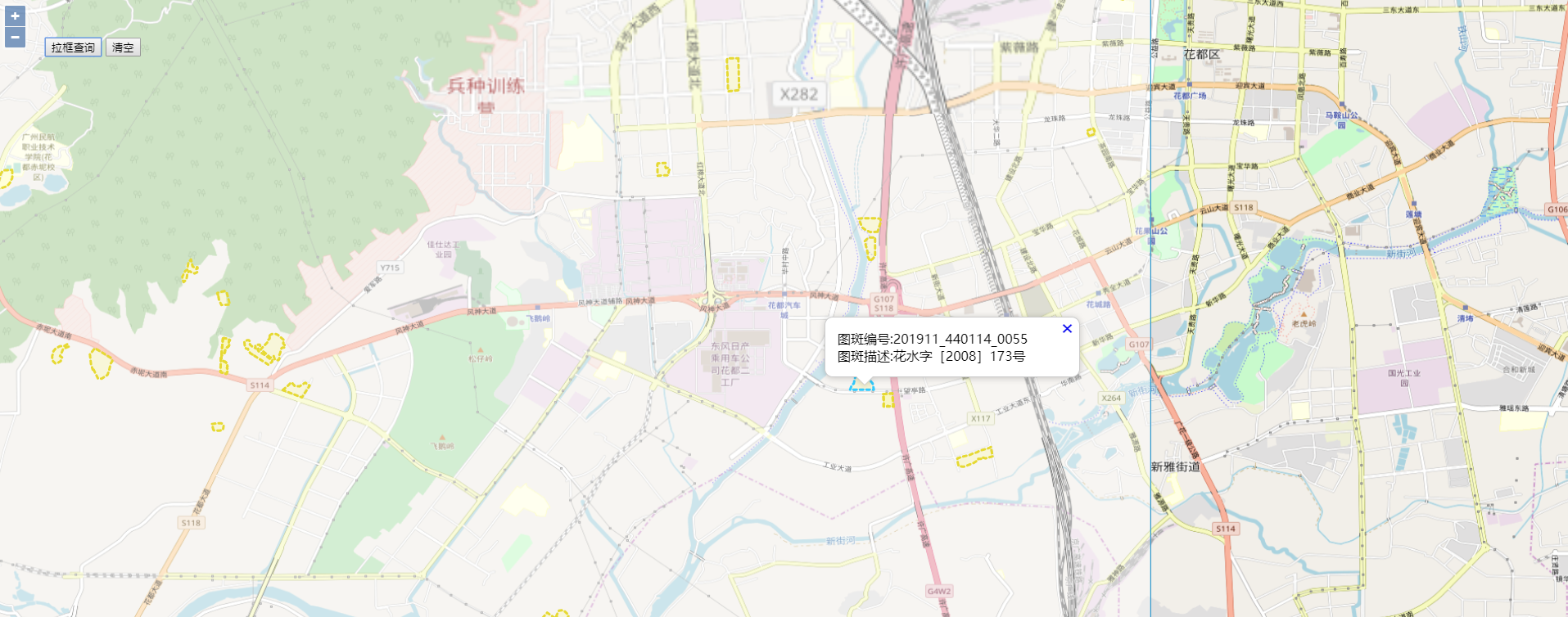
具体实现过程
- html 样式
html, body, #map {

height: 100%;

padding: 0;

margin: 0;

}

.ol-popup {

position: absolute;

background-color: white;

-webkit-filter: drop-shadow(0 1px 4px rgba(0,0,0,0.2));

filter: drop-shadow(0 1px 4px rgba(0,0,0,0.2));

padding: 15px;

border-radius: 10px;

border: 1px solid #cccccc;

bottom: 12px;

left: -50px;

min-width: 280px;

}

.ol-popup:after, .ol-popup:before {

top: 100%;

border: solid transparent;

content: " ";

height: 0;

width: 0;

position: absolute;

pointer-events: none;

}

.ol-popup:after {

border-top-color: white;

border-width: 10px;

left: 48px;

margin-left: -10px;

}

.ol-popup:before {

border-top-color: #cccccc;

border-width: 11px;

left: 48px;

margin-left: -11px;

}

.ol-popup-closer {

text-decoration: none;

position: absolute;

top: 2px;

right: 8px;

}

.ol-popup-closer:after {

content: "✖";

}
- 矢量图层默认样式以及高亮样式
//绘制geojson矢量图层样式

var geoJsonStyle = new ol.style.Style({

stroke: new ol.style.Stroke({

color: '#e6d933',

lineDash: [4],

width: 3

}),

fill: new ol.style.Fill({

color: 'rgba(255, 255, 0, 0.1)'

})

});

//绘制geojson矢量图层高亮样式

var geoJsonHLightStyle = new ol.style.Style({

stroke: new ol.style.Stroke({

color: '#33CCFF',

lineDash: [4],

width: 3

}),

fill: new ol.style.Fill({

color: 'rgba(255, 255, 0, 0.1)'

})

});
- 创建矢量图层以及绘制工具图层
var geojsonLayer = new ol.layer.Vector({

source: new ol.source.Vector(),

style: geoJsonStyle

});

//绘制工具图形

var drawsource = new ol.source.Vector();

var drawlayer = new ol.layer.Vector({

source: drawsource

});

var layers = [

new ol.layer.Tile({

source: new ol.source.OSM()

}),

/*new ol.layer.Tile({

source: new ol.source.TileArcGISRest({

url: 'https://server.arcgisonline.com/arcgis/rest/services/World_Imagery/MapServer'

})

}),*/

drawlayer,

geojsonLayer,

];
- 创建地图
var map = new ol.Map({

layers: layers,

overlays: [overlay],

target: 'map',

view: new ol.View({

projection: 'EPSG:4326',

center: [104.114129, 37.550339],

zoom: 4

})

});
- 监听地图鼠标移动事件,设置选择矢量图层要素高亮以及弹出气泡窗口效果
//监听地图鼠标移动事件

map.on('pointermove',function(e) {

if (e.dragging) {

return;

}

var feature =map.forEachFeatureAtPixel(e.pixel,

function(feature) {

return feature;

});

//console.log('feature',feature);

if(feature==undefined || !feature.values_.map_num){//捕捉不到矢量数据,设置矢量图层默认样式

geojsonLayer.getSource().forEachFeature(function(feature) {

feature.setStyle(geoJsonStyle);

});

//隐藏气泡窗口

overlay.setPosition(undefined);

closer.blur();

}else{//捕捉到矢量数据,设置矢量图层高亮样式

if(feature.values_ && feature.values_.map_num){

feature.setStyle(geoJsonHLightStyle);

//弹出气泡窗口

var coordinate = e.coordinate;

content.innerHTML = '图斑编号:'+feature.values_.map_num+'</br>图斑描述:'+feature.values_.description;

overlay.setPosition(coordinate);

}

}

})
- 空间查询核心函数
var geoserverUrl = 'http://localhost:8080/geoserver/GIS';

/*空间查询图层

*@method queryByPolygon

*@param polygon 空间范围

*@param typeName 图层名称

*@return null

*/

function queryByPolygon(polygon, typeName, callback){

var filter =

'<Filter xmlns="http://www.opengis.net/ogc" xmlns:gml="http://www.opengis.net/gml">';

filter += '<And>';

filter += '<Intersects>';

filter += '<PropertyName>geom</PropertyName>';

filter += '<gml:Polygon>';

filter += '<gml:outerBoundaryIs>';

filter += '<gml:LinearRing>';

filter += '<gml:coordinates>' + polygon + '</gml:coordinates>';

filter += '</gml:LinearRing>';

filter += '</gml:outerBoundaryIs>';

……
完整demo源码见小专栏文章尾部:GIS之家小专栏
文章尾部提供源代码下载,对本专栏感兴趣的话,可以关注一波
openlayers6结合geoserver实现地图空间查询(附源码下载)的更多相关文章
- cesium结合geoserver实现地图空间查询(附源码下载)
前言 cesium 官网的api文档介绍地址cesium官网api,里面详细的介绍 cesium 各个类的介绍,还有就是在线例子:cesium 官网在线例子,这个也是学习 cesium 的好素材. 内 ...
- leaflet 结合 geoserver 实现地图空间查询(附源码下载)
前言 leaflet 入门开发系列环境知识点了解: leaflet api文档介绍,详细介绍 leaflet 每个类的函数以及属性等等 leaflet 在线例子 leaflet 插件,leaflet ...
- openlayers6结合geoserver实现地图属性查询(附源码下载)
前言 之前写过一篇 openlayers4 版本的地图属性查询文章,但是由于是封装一层 js 代码写的,很多初学者看起来比较有点吃力,所以本篇文章重新写一篇地图属性查询文章,直接基于最新版本 open ...
- cesium 结合 geoserver 实现地图属性查询(附源码下载)
前言 cesium 官网的api文档介绍地址cesium官网api,里面详细的介绍 cesium 各个类的介绍,还有就是在线例子:cesium 官网在线例子,这个也是学习 cesium 的好素材. 内 ...
- openlayers6结合geoserver实现地图矢量瓦片(附源码下载)
内容概览 1.基于openlayers6结合geoserver实现地图矢量瓦片2.源代码demo下载 效果图如下: 实现思路:利用Geoserver发布矢量切片服务,然后openlayers调用矢量瓦 ...
- leaflet 结合 geoserver 实现地图属性查询(附源码下载)
前言 leaflet 入门开发系列环境知识点了解: leaflet api文档介绍,详细介绍 leaflet 每个类的函数以及属性等等 leaflet 在线例子 leaflet 插件,leaflet ...
- openlayers6实现webgl点图层渲染效果(附源码下载)
前言:openlayers6推出来的有一段时间,推出来的新特性见:https://github.com/openlayers/openlayers/releases/该版本的主要功能是能够组合具有不同 ...
- arcgis api 3.x for js 热力图优化篇-不依赖地图服务(附源码下载)
前言 关于本篇功能实现用到的 api 涉及类看不懂的,请参照 esri 官网的 arcgis api 3.x for js:esri 官网 api,里面详细的介绍 arcgis api 3.x 各个类 ...
- arcgis api 3.x for js 入门开发系列十一地图统计图(附源码下载)
前言 关于本篇功能实现用到的 api 涉及类看不懂的,请参照 esri 官网的 arcgis api 3.x for js:esri 官网 api,里面详细的介绍 arcgis api 3.x 各个类 ...
随机推荐
- Ubuntu18.04.3 LTS初体验
安装系统 想来虚拟机安装太慢,正好有一台旧电脑,干脆整个乌班图系统. 启动盘工具:UltraISO,老牌工具了. 上官网下载ISO镜像文件: https://cn.ubuntu.com/downloa ...
- 字体图标转base64
如果你在阿里矢量库下载了字体图标在项目引入无法显示时,可以把图标转成base64 在线转换的链接 https://transfonter.org/ css字体图标的制作
- C++中对C的扩展学习新增语法——lambda 表达式(匿名函数)
1.匿名函数基础语法.调用.保存 1.auto lambda类型 2.函数指针来保存注意点:[]只能为空,不能写东西 3.std::function来保存 2.匿名函数捕捉外部变量(值方式.引用方式) ...
- 最新版 IDEA 2019.2.4 下载安装 & 破解使用期限至2089年
一.准备 官网下载链接:https://www.jetbrains.com/idea/download/#section=windows 根据自己系统选择对应版本,这里选择Windows的UItima ...
- 使用Amazon EMR和Apache Hudi在S3上插入,更新,删除数据
将数据存储在Amazon S3中可带来很多好处,包括规模.可靠性.成本效率等方面.最重要的是,你可以利用Amazon EMR中的Apache Spark,Hive和Presto之类的开源工具来处理和分 ...
- Linux菜鸟——常见命令一 权限
Linux对文件和目录的权限位 权限位是十位 第一位 代表文件类型 - 普通文件 d 目录文件 l 链接文件 后面九尾 所有者权限 u = user 所属组权限 g = group 其他人权限 o = ...
- vue-cli从2升级到3报错error 404 Not Found: @wry/context@^0.4.0
vue3出来了,想尝尝鲜. 于是按官方的方法卸载2安装3. npm uninstall vue-cli -g npm install -g @vue/cli 但是报错了 error 404 Not F ...
- J.U.C剖析与解读1(Lock的实现)
J.U.C剖析与解读1(Lock的实现) 前言 为了节省各位的时间,我简单介绍一下这篇文章.这篇文章主要分为三块:Lock的实现,AQS的由来(通过演变的方式),JUC三大工具类的使用与原理剖析. L ...
- Viterbi(维特比)算法在CRF(条件随机场)中是如何起作用的?
之前我们介绍过BERT+CRF来进行命名实体识别,并对其中的BERT和CRF的概念和作用做了相关的介绍,然对于CRF中的最优的标签序列的计算原理,我们只提到了维特比算法,并没有做进一步的解释,本文将对 ...
- Alibaba Nacos 学习(三):Spring Cloud Nacos Discovery - FeignClient,Nacos 服务注册与发现
Alibaba Nacos 学习(一):Nacos介绍与安装 Alibaba Nacos 学习(二):Spring Cloud Nacos Config Alibaba Nacos 学习(三):Spr ...