
【代码笔记】iOS-离线地图
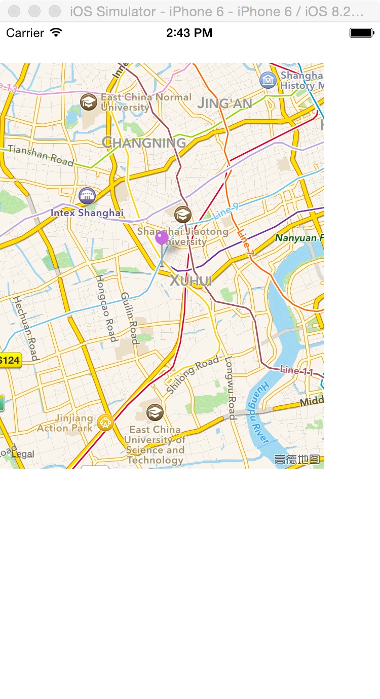
一,效果图。
二,工程图。

三,代码。
ViewController.h

#import <UIKit/UIKit.h>

#import <CoreLocation/CoreLocation.h>

#import "MapLocation.h"

@interface ViewController : UIViewController

<MKMapViewDelegate>

{

    MKMapView *_mapView;

    NSString *addressString;

}

@end
ViewController.m
#import "ViewController.h"

@interface ViewController ()

@end

@implementation ViewController

- (void)viewDidLoad {

    [super viewDidLoad];

    // Do any additional setup after loading the view.

    //调用系统自带的高德地图

    //显示当前某地的离线地图

    _mapView = [[MKMapView alloc] init];

    _mapView.frame = CGRectMake(0, 40, 320,400);

    _mapView.delegate = self;

    _mapView.mapType = MKMapTypeStandard;

    [self.view addSubview:_mapView];

    addressString=@"光启城";

    NSLog(@"---addressString---%@",addressString);

    [self geocodeQuery];

}

- (void)geocodeQuery{

    if (addressString == nil || [addressString length] == 0) {

        return;

    }

    CLGeocoder *geocoder = [[CLGeocoder alloc] init];

    [geocoder geocodeAddressString:addressString completionHandler:^(NSArray *placemarks, NSError *error) {

        NSLog(@"查询记录数:%ld",[placemarks count]);

        if ([placemarks count] > 0) {

            [_mapView removeAnnotations:_mapView.annotations];

        }

        for (int i = 0; i < [placemarks count]; i++) {

            CLPlacemark* placemark = placemarks[i];

            //调整地图位置和缩放比例

            MKCoordinateRegion viewRegion = MKCoordinateRegionMakeWithDistance(placemark.location.coordinate, 10000, 10000);

            [_mapView setRegion:viewRegion animated:YES];

            MapLocation *annotation = [[MapLocation alloc] init];

            annotation.streetAddress = placemark.thoroughfare;

            annotation.city = placemark.locality;

            annotation.state = placemark.administrativeArea;

            annotation.zip = placemark.postalCode;

            annotation.coordinate = placemark.location.coordinate;

            [_mapView addAnnotation:annotation];

        }

    }];

}

#pragma mark Map View Delegate Methods

- (MKAnnotationView *) mapView:(MKMapView *)theMapView viewForAnnotation:(id <MKAnnotation>) annotation {

    MKPinAnnotationView *annotationView

    = (MKPinAnnotationView *)[_mapView dequeueReusableAnnotationViewWithIdentifier:@"PIN_ANNOTATION"];

    if(annotationView == nil) {

        annotationView = [[MKPinAnnotationView alloc] initWithAnnotation:annotation

                                                         reuseIdentifier:@"PIN_ANNOTATION"];

    }

    annotationView.pinColor = MKPinAnnotationColorPurple;

    annotationView.animatesDrop = YES;

    annotationView.canShowCallout = YES;

    return annotationView;

}

- (void)mapView:(MKMapView *)mapView didUpdateUserLocation:(MKUserLocation *)userLocation

{

    _mapView.centerCoordinate = userLocation.location.coordinate;

}

- (void)mapViewDidFailLoadingMap:(MKMapView *)theMapView withError:(NSError *)error {

    NSLog(@"error : %@",[error description]);

}

@end
MapLocation.h
#import <MapKit/MapKit.h>

@interface MapLocation : NSObject<MKAnnotation>

//街道信息属性

@property (nonatomic, copy) NSString *streetAddress;

//城市信息属性

@property (nonatomic, copy) NSString *city;

//州、省、市信息

@property (nonatomic, copy) NSString *state;

//邮编

@property (nonatomic, copy) NSString *zip;

//地理坐标

@property (nonatomic, readwrite) CLLocationCoordinate2D coordinate;

@end
MapLocation.m
//地图调用函数

#import "MapLocation.h"

@implementation MapLocation

- (NSString *)title {

    return @"您的位置!";

}

- (NSString *)subtitle {

    NSMutableString *ret = [NSMutableString new];

    if (_state)

        [ret appendString:_state];

    if (_city)

        [ret appendString:_city];

    if (_city && _state)

        [ret appendString:@", "];

    if (_streetAddress && (_city || _state || _zip))

        [ret appendString:@" • "];

    if (_streetAddress)

        [ret appendString:_streetAddress];

    if (_zip)

        [ret appendFormat:@", %@", _zip];

    return ret;

}

@end
【代码笔记】iOS-离线地图的更多相关文章
- [转]ArcGIS移动客户端离线地图的几种解决方案
原文地址:http://blog.chinaunix.net/uid-10914615-id-3023158.html 移动GIS中,通常将数据分为两大类:basemap layer和operatio ...
- [转]MBTiles 离线地图演示 - 基于 Google Maps JavaScript API v3 + SQLite
MBTiles 是一种地图瓦片存储的数据规范,它使用SQLite数据库,可大大提高海量地图瓦片的读取速度,比通过瓦片文件方式的读取要快很多,适用于Android.IPhone等智能手机的离线地图存储. ...
- 支持WEB、Android、IOS的地图解决方案
转自原文 支持WEB.Android.IOS的地图解决方案 工具链 GIS工具集 OpenGeo Suite 包含PostGIS, GeoServer, GeoWebCache, OpenLayers ...
- 【BIGEMAP一键离线地图服务】
地址:http://www.bigemap.com/offlinemaps/ 首页 离线地图 代码示例 项目案例 开发文档 关于我们 [BIGEMAP一键离线服务] 1.快速搭建离线地图服务2 ...
- Web GIS 离线地图
Web GIS 离线地图 1,基于瓦片的离线地图下载 博客园 阿凡卢 提供了离线地图的下载工具,下载地址:http://pan.baidu.com/s/1hqvQr7e 具体使用见 参考资料2 阿凡卢 ...
- iOS原生地图开发详解
在上一篇博客中:http://my.oschina.net/u/2340880/blog/414760.对iOS中的定位服务进行了详细的介绍与参数说明,在开发中,地位服务往往与地图框架结合使用,这篇博 ...
- iOS原生地图开发进阶——使用导航和附近兴趣点检索
iOS原生地图开发进阶——使用导航和附近兴趣点检索 iOS中的mapKit框架对国际化的支持非常出色.在前些篇博客中,对这个地图框架的基础用法和标注与覆盖物的添加进行了详细的介绍,这篇博客将介绍两个更 ...
- ArcGIS for Android示例解析之离线地图-----LocalTiledLayer
转自:http://blog.csdn.net/wozaifeiyang0/article/details/7327423 LocalTiledLayer 看到这个标题是否是很激动,如题,该示例就是添 ...
- IOS开发笔记 IOS如何访问通讯录
IOS开发笔记 IOS如何访问通讯录 其实我是反对这类的需求,你说你读我的隐私,我肯定不愿意的. 幸好ios6.0 以后给了个权限控制.当打开app的时候你可以选择拒绝. 实现方法: [plain] ...
随机推荐
- Moon.Orm3.8技术全攻略
Moon.ORM技术全攻略 一.绪论 本文主要是针对Moon.ORM的技术的讨论及其使用使用指导.如有其它疑问,请留言.本文主要针对Moon.ORM3.9版本,同时将会对4.0做一个技术预览.本文从 ...
- IOS高级编程之三:IOS 多线程编程
多线程的概念在各个操作系统上都会接触到,windows.Linux.mac os等等这些常用的操作系统,都支持多线程的概念. 当然ios中也不例外,但是线程的运行节点可能是我们平常不太注意的. 例如: ...
- SQL Server时间粒度系列----第3节旬、月时间粒度详解
本文目录列表: 1.SQL Server旬时间粒度2.SQL Server月有关时间粒度 3.SQL Server函数重构 4.总结语 5.参考清单列表 SQL Server旬时间粒度 ...
- java中synchronized关键字的用法
在java编程中,经常需要用到同步,而用得最多的也许是synchronized关键字了,下面看看这个关键字的用法. 因为synchronized关键字涉及到锁的概念,所以先来了解一些相关的锁知识. j ...
- 微信开发jssdk入门
一个项目需要在微信里获得当前位置,于是就开始了我的微信开发之旅... 微信JSSDK说明文档http://mp.weixin.qq.com/wiki/7/aaa137b55fb2e0456bf8dd9 ...
- 【C#】妈妈再也不用担心自定义控件如何给特殊类型的属性添加默认值了,附自定义GroupBox一枚
------------------更新:201411190903------------------ 经过思考和实践,发现套路中的第1条是不必要的,就是完全可以不用定义一个名为Default+属性名 ...
- C++移位运算符
关于逻辑移位.算术移位可参见迅雷深大笔试题部分.的一道题. 以前看到C++标准上说,移位运算符(<<.>>)出界时的行为并不确定: The behavior is undefi ...
- WinForm小白的WPF初试一:从PropertyGrid控件,输出内容到Word(上)
学WinForm也就半年,然后转到WPF,还在熟悉中.最近拿到一个任务:从PropertyGrid控件,输出内容到Word.难点有: 一.PropertyGrid控件是WinForm控件,在WPF中并 ...
- 关于ASP.NET的“Forms身份验证”
目录结构如图如示: 如果用户没有通过身份验证则跳转到登录页面让用户登录,在配置文件的<system.web></system.web>结点下添加如下代码: <!--身份验 ...
- Struts2之Struts2-2.5.5 Interceptor
Struts2-2.5.5版本是目前为止最新的版本了,相对于之前的2.3版本以及再之前的版本而言,新版本改动了很多. 好了,废话不多说,GO CODE! 基本jar包: web.xml核心配置,这里要 ...