
Cesium加载三维路线
1. 概述
将路线加载到三维地图中,能直观显示道路的坡度变化,协同DEM和遥感影像,能极大丰富道路的可视化效果
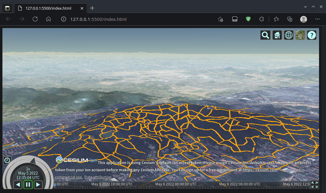
本文此处基于Cesium,加载地形数据,叠加遥感影像,再叠加路网数据,形成三维地图,效果如下:
2. 代码实现
2.1 CDN引入
笔者这里使用 CDN 引入 Cesium,另外后续加载路网数据需要使用Ajax,这里引入jQuery
<!-- Include the CesiumJS JavaScript and CSS files -->

<script src="https://cesium.com/downloads/cesiumjs/releases/1.92/Build/Cesium/Cesium.js"></script>

<link href="https://cesium.com/downloads/cesiumjs/releases/1.92/Build/Cesium/Widgets/widgets.css" rel="stylesheet">

<script src="http://libs.baidu.com/jquery/2.0.0/jquery.min.js"></script>
2.2 加载地形
笔者这里使用Cesium的地形数据
// Initialize the Cesium Viewer in the HTML element with the `cesiumContainer` ID.

var viewer = new Cesium.Viewer('cesiumContainer', {

    terrainProvider: Cesium.createWorldTerrain()

});
2.3 加载遥感影像
笔者这里使用Bing的遥感影像
var bingStyle = [

    Cesium.BingMapsStyle.AERIAL_WITH_LABELS,

    Cesium.BingMapsStyle.COLLINS_BART,

    Cesium.BingMapsStyle.CANVAS_GRAY,

    Cesium.BingMapsStyle.CANVAS_LIGHT,

    Cesium.BingMapsStyle.CANVAS_DARK,

    Cesium.BingMapsStyle.ORDNANCE_SURVEY,

    Cesium.BingMapsStyle.ROAD,

    Cesium.BingMapsStyle.AERIAL,

];

var bingMapProvider = new Cesium.BingMapsImageryProvider({

    url: "https://dev.virtualearth.net",

    key: "AmXdbd8UeUJtaRSn7yVwyXgQlBBUqliLbHpgn2c76DfuHwAXfRrgS5qwfHU6Rhm8",

    mapStyle: bingStyle[7],

});

viewer.imageryLayers.addImageryProvider(bingMapProvider);
2.4 设置视点
笔者这里将视点即观察点设置为长沙岳麓山附近
// Fly the camera to Changsha at the given longitude, latitude, and height.

viewer.camera.flyTo({

    destination: Cesium.Cartesian3.fromDegrees(112.9448, 28.1708, 1200),

    orientation: {

        heading: Cesium.Math.toRadians(0.0),

        pitch: Cesium.Math.toRadians(-15.0),

    }

});
2.5 小结测试
到目前为止,整体代码如下:
<!DOCTYPE html>

<html lang="zh-cn">

<head>

    <meta charset="utf-8">

    <!-- Include the CesiumJS JavaScript and CSS files -->

    <script src="https://cesium.com/downloads/cesiumjs/releases/1.92/Build/Cesium/Cesium.js"></script>

    <link href="https://cesium.com/downloads/cesiumjs/releases/1.92/Build/Cesium/Widgets/widgets.css" rel="stylesheet">

    <script src="http://libs.baidu.com/jquery/2.0.0/jquery.min.js"></script>

</head>

<body>

    <div id="cesiumContainer"></div>

    <script>

        // Your access token can be found at: https://cesium.com/ion/tokens.

        // Replace `your_access_token` with your Cesium ion access token.

        // Cesium.Ion.defaultAccessToken = 'your_access_token';

        // Initialize the Cesium Viewer in the HTML element with the `cesiumContainer` ID.

        var viewer = new Cesium.Viewer('cesiumContainer', {

            terrainProvider: Cesium.createWorldTerrain()

        });

        var bingStyle = [

            Cesium.BingMapsStyle.AERIAL_WITH_LABELS,

            Cesium.BingMapsStyle.COLLINS_BART,

            Cesium.BingMapsStyle.CANVAS_GRAY,

            Cesium.BingMapsStyle.CANVAS_LIGHT,

            Cesium.BingMapsStyle.CANVAS_DARK,

            Cesium.BingMapsStyle.ORDNANCE_SURVEY,

            Cesium.BingMapsStyle.ROAD,

            Cesium.BingMapsStyle.AERIAL,

        ];

        var bingMapProvider = new Cesium.BingMapsImageryProvider({

            url: "https://dev.virtualearth.net",

            key: "AmXdbd8UeUJtaRSn7yVwyXgQlBBUqliLbHpgn2c76DfuHwAXfRrgS5qwfHU6Rhm8",

            mapStyle: bingStyle[7],

        });

        viewer.imageryLayers.addImageryProvider(bingMapProvider);

        // Fly the camera to Changsha at the given longitude, latitude, and height.

        viewer.camera.flyTo({

            destination: Cesium.Cartesian3.fromDegrees(112.9448, 28.1708, 1200),

            orientation: {

                heading: Cesium.Math.toRadians(0.0),

                pitch: Cesium.Math.toRadians(-15.0),

            }

        });

    </script>

    </div>

</body>

</html>
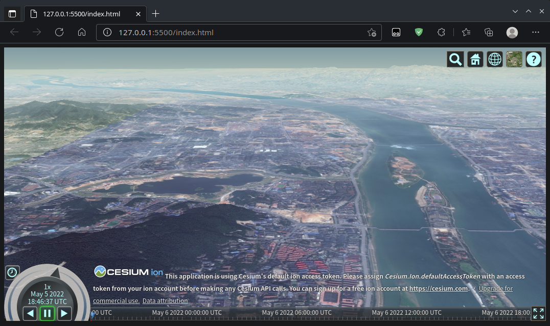
我们测试其效果,笔者这里使用的是VS Code的Live Server插件打开:
2.6 路网加载
路网(Ployline)的加载方式主要有两种:
- 使用
Viewer.entities - 使用
Cesium.GroundPolylinePrimitive
此处笔者的示例数据如下:
112.91725386767241,28.18088394284931,47.28909519744873

112.91765398304703,28.18080062181755,52.27461015478515

112.94271541045252,28.18907071666184,34.729803589843755

112.94263996370492,28.18929672498712,44.796474171875005

112.94263996370492,28.18929672498712,44.796474171875005

112.94271541045252,28.18907071666184,34.729803589843755

112.94264628370074,28.190083096717974,36.39323925

112.94259227750655,28.18977721403619,24.70917075

112.94259227750655,28.18977721403619,24.70917075

112.94264628370074,28.190083096717974,36.39323925

112.94264628370074,28.190083096717974,36.39323925

112.94255004568583,28.19039785102342,46.969459281249996

112.94255004568583,28.19039785102342,46.969459281249996

112.94264628370074,28.190083096717974,36.39323925

112.94263996370492,28.18929672498712,44.796474171875005

112.942639007202,28.18939392688125,41.37971635546875

112.942639007202,28.18939392688125,41.37971635546875

112.94263996370492,28.18929672498712,44.796474171875005

112.942639007202,28.18939392688125,41.37971635546875

112.94259227750655,28.18977721403619,24.70917075

112.94259227750655,28.18977721403619,24.70917075

112.942639007202,28.18939392688125,41.37971635546875

112.94255707716033,28.19747999678687,78.00138119911344

112.94251096347146,28.197641540468794,62.308529711560176

112.94251096347146,28.197641540468794,62.308529711560176

112.94251086130572,28.19765191789022,62.308529711560176

112.94251086130572,28.19765191789022,62.308529711560176

112.94216077246415,28.19774676732831,88.14892901957208

112.94251096347146,28.197641540468794,62.308529711560176

112.94255707716033,28.19747999678687,78.00138119911344

112.94251086130572,28.19765191789022,62.308529711560176

112.94251096347146,28.197641540468794,62.308529711560176
数据文件的名字为trans_final_map_with_dem.csv,笔者使用Ajax加载并解析
前者Viewer.entities的代码如下:
$.ajax({

    url: 'trans_final_map_with_dem.csv',

    dataType: 'text',

}).done(successFunction);

var groundPolylineGeometryInstances = [];

function successFunction(data) {

    var allRows = data.split(/\r?\n|\r/);

    for (let i = 0; i < allRows.length - 1; i = i + 2) {

        var rowCell1 = allRows[i].split(',');

        var rowCell2 = allRows[i + 1].split(',');

        viewer.entities.add({

            polyline: {

                positions: Cesium.Cartesian3.fromDegreesArrayHeights([

                    rowCell1[0], rowCell1[1],rowCell1[2],

                    rowCell2[0], rowCell2[1],rowCell2[2]

                ]),

                width: 4.0,

                material: Cesium.Color.ORANGE,

                clampToGround: true

            }

        })

    }

}
后者Cesium.GroundPolylinePrimitive的代码如下:
$.ajax({

    url: 'trans_final_map_with_dem.csv',

    dataType: 'text',

}).done(successFunction);

var groundPolylineGeometryInstances = [];

function successFunction(data) {

    var allRows = data.split(/\r?\n|\r/);

    for (let i = 0; i < allRows.length - 1; i = i + 2) {

        var rowCell1 = allRows[i].split(',');

        var rowCell2 = allRows[i + 1].split(',');

        groundPolylineGeometryInstances.push(new Cesium.GeometryInstance({

            geometry: new Cesium.GroundPolylineGeometry({

                positions: Cesium.Cartesian3.fromDegreesArrayHeights([

                    rowCell1[0], rowCell1[1], rowCell1[2],

                    rowCell2[0], rowCell2[1], rowCell2[2]

                ]),

                width: 4.0,

            }),

            attributes: {

                color: Cesium.ColorGeometryInstanceAttribute.fromColor(Cesium.Color.ORANGE.withAlpha(1.0))

            }

        }));

    }

    var groundPolylinePrimitive = new Cesium.GroundPolylinePrimitive({

        geometryInstances: groundPolylineGeometryInstances,

        show: true,

        appearance: new Cesium.PolylineColorAppearance()

    });

    viewer.scene.groundPrimitives.add(groundPolylinePrimitive)

}
注意:
- 笔者这里的数据是每两个点构成一个Polyline,每一行最后是换行符'\n'
- 数据量大时尽可能使用
Cesium.GroundPolylinePrimitive
2.7 最终测试
整体代码如下:
<!DOCTYPE html>

<html lang="zh-cn">

<head>

    <meta charset="utf-8">

    <!-- Include the CesiumJS JavaScript and CSS files -->

    <script src="https://cesium.com/downloads/cesiumjs/releases/1.92/Build/Cesium/Cesium.js"></script>

    <link href="https://cesium.com/downloads/cesiumjs/releases/1.92/Build/Cesium/Widgets/widgets.css" rel="stylesheet">

    <script src="http://libs.baidu.com/jquery/2.0.0/jquery.min.js"></script>

</head>

<body>

    <div id="cesiumContainer"></div>

    <script>

        // Your access token can be found at: https://cesium.com/ion/tokens.

        // Replace `your_access_token` with your Cesium ion access token.

        // Cesium.Ion.defaultAccessToken = 'your_access_token';

        // Initialize the Cesium Viewer in the HTML element with the `cesiumContainer` ID.

        var viewer = new Cesium.Viewer('cesiumContainer', {

            terrainProvider: Cesium.createWorldTerrain()

        });

        var bingStyle = [

            Cesium.BingMapsStyle.AERIAL_WITH_LABELS,

            Cesium.BingMapsStyle.COLLINS_BART,

            Cesium.BingMapsStyle.CANVAS_GRAY,

            Cesium.BingMapsStyle.CANVAS_LIGHT,

            Cesium.BingMapsStyle.CANVAS_DARK,

            Cesium.BingMapsStyle.ORDNANCE_SURVEY,

            Cesium.BingMapsStyle.ROAD,

            Cesium.BingMapsStyle.AERIAL,

        ];

        var bingMapProvider = new Cesium.BingMapsImageryProvider({

            url: "https://dev.virtualearth.net",

            key: "AmXdbd8UeUJtaRSn7yVwyXgQlBBUqliLbHpgn2c76DfuHwAXfRrgS5qwfHU6Rhm8",

            mapStyle: bingStyle[7],

        });

        viewer.imageryLayers.addImageryProvider(bingMapProvider);

        $.ajax({

            url: 'trans_final_map_with_dem.csv',

            dataType: 'text',

        }).done(successFunction);

        // const polylines = new Cesium.PolylineCollection();

        var groundPolylineGeometryInstances = [];

        function successFunction(data) {

            var allRows = data.split(/\r?\n|\r/);

            for (let i = 0; i < allRows.length - 1; i = i + 2) {

                var rowCell1 = allRows[i].split(',');

                var rowCell2 = allRows[i + 1].split(',');

                //     viewer.entities.add({

                //         polyline: {

                //             positions: Cesium.Cartesian3.fromDegreesArrayHeights([

                //                 rowCell1[0], rowCell1[1],rowCell1[2],

                //                 rowCell2[0], rowCell2[1],rowCell2[2]

                //             ]),

                //             width: 4.0,

                //             material: Cesium.Color.ORANGE,

                //             clampToGround: true

                //         }

                //     })

                // }

                groundPolylineGeometryInstances.push(new Cesium.GeometryInstance({

                    geometry: new Cesium.GroundPolylineGeometry({

                        positions: Cesium.Cartesian3.fromDegreesArrayHeights([

                            rowCell1[0], rowCell1[1], rowCell1[2],

                            rowCell2[0], rowCell2[1], rowCell2[2]

                        ]),

                        width: 4.0,

                    }),

                    attributes: {

                        color: Cesium.ColorGeometryInstanceAttribute.fromColor(Cesium.Color.ORANGE.withAlpha(1.0))

                    }

                }));

                // }

            }

            var groundPolylinePrimitive = new Cesium.GroundPolylinePrimitive({

                geometryInstances: groundPolylineGeometryInstances,

                show: true,

                appearance: new Cesium.PolylineColorAppearance()

            });

            viewer.scene.groundPrimitives.add(groundPolylinePrimitive)

        }

        // Fly the camera to Changsha at the given longitude, latitude, and height.

        viewer.camera.flyTo({

            destination: Cesium.Cartesian3.fromDegrees(112.9448, 28.1708, 1200),

            orientation: {

                heading: Cesium.Math.toRadians(0.0),

                pitch: Cesium.Math.toRadians(-15.0),

            }

        });

    </script>

    </div>

</body>

</html>
最后效果如下:
参考资料
[1]Sandcastle
[4]遥感影像和DEM数据获取处理、GeoServer切片发布并使用Cesium加载
Cesium加载三维路线的更多相关文章
- Cesium加载三维倾斜摄影数据
具体技术来源自论文 基于Cesium的倾斜摄影三维模型Web加载与应用研究. 技术架构图 应用实例 利用一个实际实例来详细说明如何利用Cesium加载倾斜摄影数据,并进行可视化和交互操作. 首先,利用 ...
- cesium加载倾斜摄影,添加billboard并注册点击事件
完整示例代码如下: <!DOCTYPE html> <html lang="en"> <head> <meta charset=" ...
- arcgis api for JavaScript _加载三维图层(scene layer)
arcgis api for JavaScript _加载三维图层(scene layer) arcgis api for JavaScript 4.x 版本增加对三维的支持. 关于三维图层(sce ...
- cesium加载gltf模型
cesium加载gltf模型 一.采用vue-cesium:在项目里加载依赖包.命令如下: npm i --save vue-cesium 在main.js中加入如下代码: https://www.n ...
- Cesium加载地形数据只显示半个地球
Cesium第0级地形包括两个瓦片:0/0/0.terrain,0/1/0.terrain,分别为左半球和右半球(具体参考:https://blog.csdn.net/u013929284/artic ...
- cesium加载gltf模型点击以及列表点击定位弹窗
前言 cesium 官网的api文档介绍地址cesium官网api,里面详细的介绍 cesium 各个类的介绍,还有就是在线例子:cesium 官网在线例子,这个也是学习 cesium 的好素材. 之 ...
- geotrellis使用(三十五)Cesium加载geotrellis TMS瓦片
前言 做任何事情都不是想象中的那么简单.好久没有更新技术博客了,跟最近瞎忙有很大关系,虽说是瞎忙也抽空研究了些技术. 主要是前端渲染,像原生的WebGL和Cesium.WebGL写了几篇博客,自我感觉 ...
- cesium 加载倾斜摄影模型(这里有一坑)
代码如下: // Construct the default list of terrain sources. var terrainModels = Cesium.createDefaultTerr ...
- cesium 加载TMS影像(已经切片)
TMS影像数据格式 加载影像的代码: var layers = viewer.scene.imageryLayers; var blackMarble = layers.addImageryProvi ...
- cesium 加载shp格式的白模建筑
ceisum加载shp格式的建筑.有两种思路,目前推荐第二种. 方法一:将shp格式转换为geojson格式,然后采用cesium提供的接口加载到ceisum中. 严重缺陷:在面对大场景问题,即数据量 ...
随机推荐
- vue设计与实现 第6章 ref 响应原理 笔记
ref 函数实现代码 const a = ref(1); function ref(value){ const wrapper = {value} Object.defineProperty(wrap ...
- 基于EasyCode定制Mybatisplus全自动单表实现:新增/批量新增/修改/批量删除/分页查询/ID查询
基于EasyCode定制Mybatisplus全自动单表实现CRUD接口 分页查询 ID查询 新增 批量新增 修改 批量删除 注意使用了MybatisPlus的自动填充功能,和insertBatchS ...
- Navicat破解教程
一.注意: 软件适用于WIN7/8/10/11: 安装全程断网: 下载.解压和安装都应该在英文路径下进行: 解压安装前关闭所有杀毒软件,WIN10/11系统需关闭Windows Defender的实时 ...
- 英华学堂网课助手Linux版本
首先我们下去GitHub把文件下载下来记得 脚本地址: https://github.com/aoaostar/mooc/releases/latest 这几个版本随便下哪个都可以,下载完之后我们通过 ...
- CH579(Cortex-M0)网络IAP升级介绍及问题解答--(持续更新) 网络升级
CH579网络IAP升级的源码可以从码云(Gitee)上git clone下来. 码云地址:https://gitee.com/maji19971221/wch-ch57x 以下是一个朋友问的几个常见 ...
- 在 C# 9 中使用 foreach 扩展
在 C# 9 中,foreach 循环可以使用扩展方法.在本文中,我们将通过例子回顾 C# 9 中如何扩展 foreach 循环. 代码演示 下面是一个对树形结构进行深度优先遍历的示例代码: usin ...
- MySQL union 和 order by 同时使用
目录 一.出现错误的情况 二.解决上述问题的两种方法 三.案例分析: 求解: 常见的错误解法 (1)使用 union 和 多个order by 不加括号 [报错] (2)order by 在 unio ...
- day09-AOP-02
AOP-02 4.问题提出 在上一篇的MyProxyProvider类中,我们的输出语句功能比较弱,在实际开发中,我们希望是以一个方法的形式,嵌入到真正执行的目标方法前,怎么办? 1.使用土方法解决 ...
- flutter Error:Cannot run with sound null safety, because the following dependencies don't support
学习flutter新版本的路上,真的是一天一个新惊喜啊 今天遇到的坑是 Flutter 升级高版本后,运行和build 报错 Error: Cannot run with sound null saf ...
- 新下载了一个框架,然后npm install时候报错npm ERR! Maximum call stack size exceeded
今天遇到这个npm ERR! Maximum call stack size exceeded报错 解决方案如下: 1.更新npm版本 //查看版本 npm -v //更新 npm install - ...