GeoServer中WMS、WFS的请求规范(转载)
1.背景
1.1WMS简介
Web地图服务(WMS)利用具有地理空间位置信息的数据制作地图。其中将地图定义为地理数据可视的表现。这个规范定义了三个操作:GetCapabitities返回服务级元数据,它是对服务信息内容和要求参数的一种描述; GetMap返回一个地图影像,其地理空间参考和大小参数是明确定义了的;GetFeatureInfo(可选)返回显示在地图上的某些特殊要素的信息。
GeoServer官网上对其WMS规范的描述地址为http://docs.geoserver.org/stable/en/user/services/wms/index.html。
1.2WFS简介
Web要素服务(WFS)返回的是要素级的GML编码,并提供对要素的增加、修改、删除等事务操作,是对Web地图服务的进一步深入。OGC Web要素服务允许客户端从多个Web要素服务中取得使用地理标记语言(GML)编码的地理空间数据,这个远东定义了五个操作:GetCapabilites返回Web要素服务性能描述文档(用XML描述);DescribeFeatureType返回描述可以提供服务的任何要素结构的XML文档;GetFeature为一个获取要素实例的请求提供服务;Transaction为事务请求提供服务;LockFeature处理在一个事务期间对一个或多个要素类型实例上锁的请求。
GeoServer官网上对其WFS规范的描述地址为http://docs.geoserver.org/stable/en/user/services/wfs/index.html。
2.WMS请求规范详解
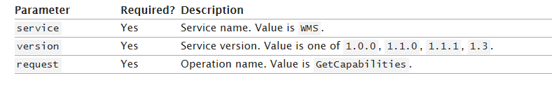
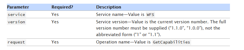
2.1GetCapabitities(返回服务级元数据)
URL例子:
http://localhost:8680/geoserver/wms?service=wms&version=1.1.1&request=GetCapabilities。
参数意义:
返回结果:
其返回结果为一个描述性XML文档,包含了以下三个要素:

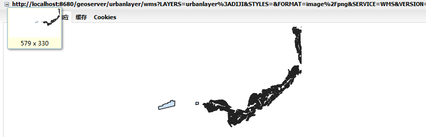
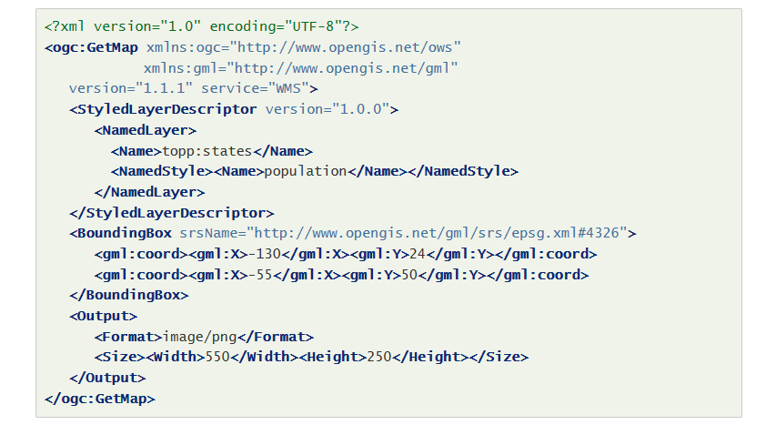
2.2GetMap(获取影像)
URL例子:
参数意义:
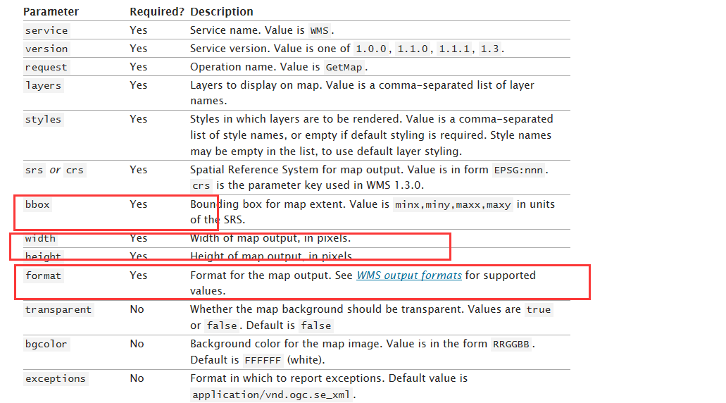
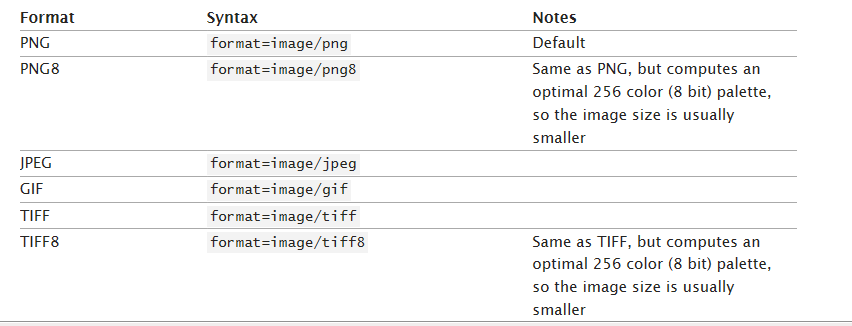
这里对返回的格式(format)有如下选择:
返回结果:
注意:此请求同样支持XML格式请求,如下:
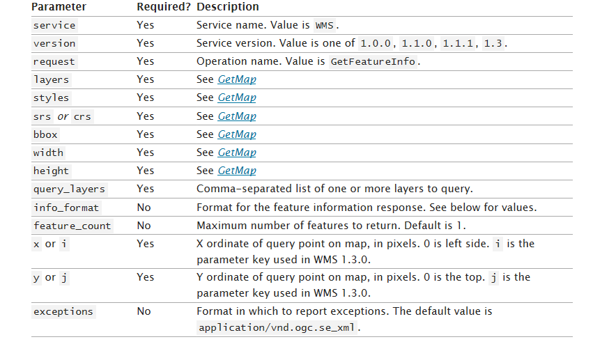
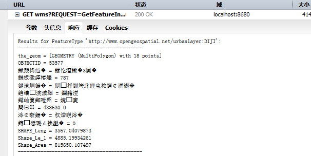
2.3GetFeatureInfo(返回要素信息)
URL例子:
参数意义:
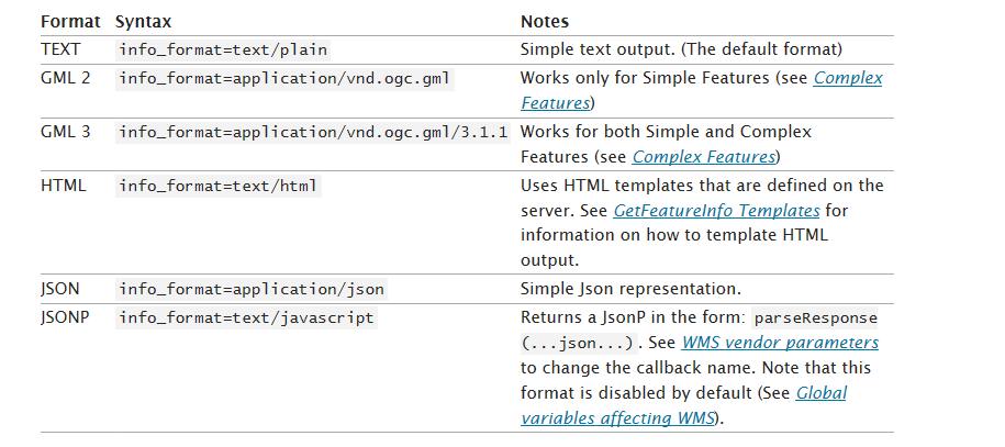
这里对返回的文本格式(info_format)有如下选择:
返回结果(忽略中文乱码):
3.WFS请求规范
3.1GetCapabilities(返回服务描述文档)
URL例子:
http://localhost:8680/geoserver/wfs?service=wfs&version=1.1.0&request=GetCapabilities。
参数意义:
返回结果:
返回的结果为描述性XML,包含以下五个主要部分:

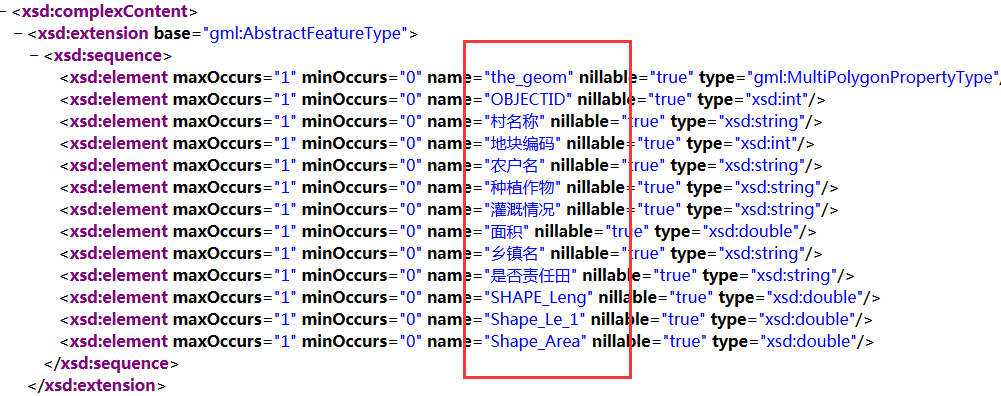
3.2DescribeFeatureType(返回图层描述信息)
URL例子:
参数意义:
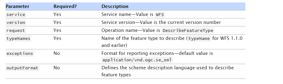
返回结果:
3.3GetFeature(获取图层要素)
3.3.1GET查询
这里首先给出一个例子:
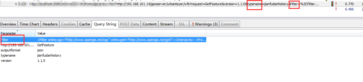
此请求常见的参数有:typeNames,featureID,propertyName,Filter, count, sortBy。其中Filter参数最为重要,主要负责进行选择过滤。关于Filter的具体描述可参考:http://docs.geoserver.org/stable/en/user/filter/function.html。
返回结果为:
{"type":"FeatureCollection","features":[{"type":"Feature","id":"jianfudan.322","geometry":{"type":"MultiPolygon","coordinates":[[[[30.276436000822056,120.20021],[30.275750000822033,120.20021],[30.22768400082126,120.22562],[30.245537000821543,120.17343000000001],[30.276436000822056,120.20021]]]]},"geometry_name":"the_geom","properties":{"limitid":71,"displayorder":null,"regionid":3,"validfromdate":"2016-05-15Z","validtodate":"2016-06-14Z","validflag":1,"media":null,"shape_length":null,"shape_area":null,"graphicid":322,"regionname":"江干区","eventtypes":null,"otherrequest":null,"limitname":"上报区域71"}},{"type":"Feature","id":"jianfudan.318","geometry":{"type":"MultiPolygon","coordinates":[[[[30.26407600082185,120.19668600000001],[30.26407600082185,120.196434],[30.262875000821833,120.20785],[30.24708200082157,120.203896],[30.255150000821704,120.187164],[30.26407600082185,120.19668600000001]]]]},"geometry_name":"the_geom","properties":{"limitid":72,"displayorder":null,"regionid":3,"validfromdate":"2016-05-04Z","validtodate":"2016-06-03Z","validflag":1,"media":"http://172.18.6.197:8081/MediaRoot/null/20160505/72/84989ee1-9bab-4640-8f24-4a7381f1c4e8/机票预订.png","shape_length":null,"shape_area":null,"graphicid":318,"regionname":"江干区","eventtypes":"乱搭乱建,暴露垃圾,积存垃圾渣土,路面不洁,河道不洁(含沟渠、湖面)","otherrequest":"测试","limitname":"上报区域72"}}],"crs":{"type":"EPSG","properties":{"code":"4490"}}}
3.3.1.1点查询Filter
<Filter xmlns:ogc="http://www.opengis.net/ogc" xmlns:gml="http://www.opengis.net/gml">
<Intersects>
<PropertyName>the_geom</PropertyName>
<gml:Envelope srsName="EPSG:4326">
<gml:lowerCorner>120.15336460382575 30.2743621901609</gml:lowerCorner>
<gml:upperCorner>120.167097513982 30.28809510031715</gml:upperCorner>
</gml:Envelope>
</Intersects>
</Filter>
3.3.1.2自定义多边形查询Filter
<Filter xmlns:ogc="http://www.opengis.net/ogc" xmlns:gml="http://www.opengis.net/gml">
<Intersects>
<PropertyName>the_geom</PropertyName>
<gml:MultiPolygon srsName="EPSG:4326">
<gml:polygonMember>
<gml:Polygon>
<gml:outerBoundaryIs>
<gml:LinearRing>
<gml:coordinates xmlns:gml="http://www.opengis.net/gml" decimal="." cs="," ts="">
120.15677,30.2557 120.15677,30.26351 120.16833,30.26351 120.16833,30.2557 120.15677,30.2557
</gml:coordinates>
</gml:LinearRing>
</gml:outerBoundaryIs>
</gml:Polygon>
</gml:polygonMember>
</gml:MultiPolygon>
</Intersects>
</Filter>
3.3.2Post查询
因为GET请求的数据量大小在4kb以内,所以Post为更常用的方法。以下为一个具体的例子:

其中直接发送的为一个XML文件,其Filter中可以填写的内容和GET中的Filter一样。
具体内容如下:
<?xml version='1.0' encoding='GBK'?><wfs:GetFeature service='WFS' version='1.0.0' outputFormat='JSON'
xmlns:wfs='http://www.opengis.net/wfs'
xmlns:ogc='http://www.opengis.net/ogc'
xmlns:gml='http://www.opengis.net/gml' xmlns:xsi='http://www.w3.org/2001/XMLSchema-instance' xsi:schemaLocation='http://www.opengis.net/wfs http://schemas.opengis.net/wfs/1.0.0/WFS-basic.xsd'>
<wfs:Query typeName='cell'>
<wfs:PropertyName>the_geom</wfs:PropertyName>
<wfs:PropertyName>test1</wfs:PropertyName>
<ogc:Filter>
<Or>
<PropertyIsEqualTo><PropertyName>test1</PropertyName><Literal>valuetest1</Literal></PropertyIsEqualTo>
<PropertyIsEqualTo><PropertyName>test2</PropertyName><Literal>valuetest2</Literal></PropertyIsEqualTo>
</Or>
</ogc:Filter>
</wfs:Query>
</wfs:GetFeature>
3.4 Transaction(编辑要素)
该方法支持对要素的增删改。这里直接给出Post请求中发送的XML组织格式:
3.4.1添加要素
<wfs:Transaction service="WFS" version="1.0.0"
outputFormat="GML2"
xmlns:opengis="http://www.cetusOpengis.com"
xmlns:wfs="http://www.opengis.net/wfs"
xmlns:ogc="http://www.opengis.net/ogc"
xmlns:gml="http://www.opengis.net/gml"
xmlns:xsi="http://www.w3.org/2001/XMLSchema-instance"
xsi:schemaLocation="http://www.opengis.net/wfs http://schemas.opengis.net/wfs/1.0.0/WFS-basic.xsd">
<wfs:Insert handle="someprj1">
<opengis:someprj>
<opengis:the_geom>
<gml:Point srsName="http://www.opengis.net/gml/srs/epsg.xml#3395" >
<gml:coordinates decimal="." cs="," ts="">13404701.212,3850391.781</gml:coordinates>
</gml:Point>
</opengis:the_geom>
<opengis:ssds>13</opengis:ssds>
<opengis:qqybh>12</opengis:qqybh>
<opengis:status>0</opengis:status>
</opengis:someprj>
</wfs:Insert>
</wfs:Transaction>
3.4.2修改要素
<wfs:Transaction service="WFS" version="1.0.0"
outputFormat="GML2"
xmlns:opengis="http://www.cetusOpengis.com"
xmlns:wfs="http://www.opengis.net/wfs"
xmlns:ogc="http://www.opengis.net/ogc"
xmlns:gml="http://www.opengis.net/gml"
xmlns:xsi="http://www.w3.org/2001/XMLSchema-instance"
xsi:schemaLocation="http://www.opengis.net/wfs http://schemas.opengis.net/wfs/1.0.0/WFS-basic.xsd">
<wfs:Update typeName="opengis:qqyproject">
<wfs:Property>
<wfs:Name>qqybh</wfs:Name>
<wfs:Value>12</wfs:Value>
</wfs:Property>
<ogc:Filter>
<ogc:PropertyIsEqualTo>
<ogc:PropertyName>qqybh</ogc:PropertyName>
<ogc:Literal>0</ogc:Literal>
</ogc:PropertyIsEqualTo>
</ogc:Filter>
</wfs:Update>
</wfs:Transaction>
3.4.3删除要素
<wfs:Transaction service="WFS" version="1.0.0"
outputFormat="GML2"
xmlns:opengis="http://www.cetusOpengis.com"
xmlns:wfs="http://www.opengis.net/wfs"
xmlns:ogc="http://www.opengis.net/ogc"
xmlns:gml="http://www.opengis.net/gml"
xmlns:xsi="http://www.w3.org/2001/XMLSchema-instance"
xsi:schemaLocation="http://www.opengis.net/wfs http://schemas.opengis.net/wfs/1.0.0/WFS-basic.xsd">
<wfs:Delete typeName="opengis:qqyproject">
<ogc:Filter>
<ogc:PropertyIsLessThan>
<ogc:PropertyName>qqybh</ogc:PropertyName>
<ogc:Literal>12</ogc:Literal>
</ogc:PropertyIsLessThan>
<ogc:PropertyIsGreaterThan>
<ogc:PropertyName>qqybh</ogc:PropertyName>
<ogc:Literal>0</ogc:Literal>
</ogc:PropertyIsGreaterThan>
</ogc:Filter>
</wfs:Delete>
</wfs:Transaction>
4.总结
a.动态出图可以使用WMS中的GetMap请求。
b.矢量查询可以使用WFS中的GetFeature请求。
c.要素编辑可以使用WFS中的Transaction请求。
--------------------------------------------------------------------------------------------------------------------------------
注:本文转载于博客园李晓晖个人博客Naa(http://www.cnblogs.com/naaoveGIS/),感谢原文作者!
GeoServer中WMS、WFS的请求规范(转载)的更多相关文章
- geoserver中WMS服务详细说明
官方geoserver中WMS服务中几种操作的API的详细说明地址: http://docs.geoserver.org/stable/en/user/services/wms/reference.h ...
- GeoServer中WMS、WFS的请求规范
文章版权由作者李晓晖和博客园共有,若转载请于明显处标明出处:http://www.cnblogs.com/naaoveGIS/ 1.背景 1.1WMS简介 Web地图服务(WMS)利用具有地理空间位置 ...
- GeoServer中使用样式化图层描述符(sld)给WMS加注记
现有一个shp格式的道路注记文件,用点来表示注记的位置,属性表中保存每个点对应的字,在QGIS中打开如下图所示 它的属性表如下 现需要把道路数据和它的注记发布为WMS服务,通过GeoServer直接发 ...
- gis笔记 wms wfs等OGC标准
WFS 和WMS的区别 WFS是基于地理要素级别的数据共享和数据操作,WFS规范定义了若干基于地理要素(Feature)级别的数据操作接口,并以 HTTP 作为分布式计算平台.通过 WFS服务,客户端 ...
- 简析Geoserver中获取图层列表以及各图层描述信息的三种方法
文章版权由作者李晓晖和博客园共有,若转载请于明显处标明出处:http://www.cnblogs.com/naaoveGIS/. 1.背景 实际项目中需要获取到Geoserver中的图层组织以及各图层 ...
- GeoServer中GeoWebCache(GWC)的使用
本文介绍GeoWebCache的使用方法,包括如何切缓存,访问缓存wms/wmts服务,如何复用栅格缓存等. 文章大部分内容转载自https://www.cnblogs.com/naaoveGIS/p ...
- GeoServer中利用SLD配图之矢量图层配图
文章版权由作者李晓晖和博客园共有,若转载请于明显处标明出处:http://www.cnblogs.com/naaoveGIS/. 1 背景 我们在ArcMap中可以直接通过symbol功能对图层进行定 ...
- Web Api 中Get 和 Post 请求的多种情况分析
转自:http://www.cnblogs.com/babycool/p/3922738.html 来看看对于一般前台页面发起的get和post请求,我们在Web API中要如何来处理. 这里我使用J ...
- openlayers 3加载GeoServer发布的wfs类型服务
转:https://blog.csdn.net/u013323965/article/details/52449502 问题产生: openlayer3加载WFS存在跨域问题,需要用json ...
随机推荐
- Web开发模式
原文链接 开发模式的介绍(完善版) 在Web开发模式中,有两个主要的开发结构,称为模式一(Mode I)和模式二(Mode II). 首先我们来理清一些概念吧: DAO(Data Access Obj ...
- Linux安装Elasticsearch-head插件
首先需要下载以下内容: 我试验的对应版本:ES:elasticsearch-6.6.1.tar.gz Node:node-v10.15.3-linux-x64.tar JDK:jdk-8u201- ...
- 40个迹象表明你还是PHP菜鸟
你是PHP菜鸟,如果你: 1. 不会利用如phpDoc这样的工具来恰当地注释你的代码2. 对优秀的集成开发环境如Zend Studio或Eclipse PDT视而不见3. 从未用过任何形式的版本控制系 ...
- 封装通用的xhr对象(兼容各个版本)
<!DOCTYPE html> <html lang="en"> <head> <meta charset="UTF-8&quo ...
- UGUI Slider的onValueChanged事件
在本文,你将学到如何将UGUI Slider的onValueChanged事件进行统一管理. using System; using UnityEngine; using UnityEngine.UI ...
- 前端cookie、localStorage、sessionStorage缓存技术总结
转载自:https://www.cnblogs.com/belove8013/p/8134067.html 1.Cookie JavaScript是运行在客户端的脚本,因此一般是不能够设置Sessio ...
- lua-redis-parser module
https://github.com/openresty/lua-redis-parser 此模块主要是处理redis请求和响应的. local parser = require "redi ...
- ionic3打包打包安卓apk详细过程以及遇到的问题
1.jdk和sdk的安装以及环境变量配置参考打包详解 上述连接已经从下载安装jdk以及sdk的环境变量配置到打包的流程以及很详细了.但是在我自己安装打包的过程中遇到了这篇文章中没有遇到的问题,下面图文 ...
- oracle 表空间tablespace
一.Oracle 表空间的组成 Everoone knows Oracle数据库真正存放数据的是数据文件,Oracle表空间是逻辑上的概念,他在物理上是并不存在的,把多个DataFile合并到一起就是 ...
- ORACLE迁移GP实践
最近在做oracle到greenplum的迁移实践,步骤如下: 1. 使用ora2pg实现Oracle的数据结构迁移到GP的实现过程 2. Oracle的数据迁移到GP的实现过程 1. ora2p ...