使用PostGIS完成两点间的河流轨迹及流经长度的计算
基础准备工作
1.PostGIS 的安装
在安装PostGIS前首先必须安装PostgreSQL,然后再安装好的Stack Builder中选择安装PostGIS组件。具体安装步骤可参照 PostGIS的安装与初步使用_不睡觉的怪叔叔的博客-CSDN博客_postgis
2.加载Post GIS扩展
选中指定数据库,执行加载扩展语句
–添加支持

CREATE EXTENSION postgis;  --添加postgis扩展

CREATE EXTENSION pgrouting;   --添加pgrouting扩展

CREATE EXTENSION postgis_topology;

CREATE EXTENSION fuzzystrmatch;

CREATE EXTENSION postgis_tiger_geocoder;
在做两点间河流轨迹及流经长度计算过程中,需要加载postgis和pgrouting两个扩展
可以通过查看加载扩展的版本验证扩展加载是否成功
–查看postgresql版本

show server_version;

–查看postgis版本

SELECT PostGIS_full_version();

–查看pgrouting版本

select pgr_version();
3.河流矢量图层转成单线格式
河流包括各种汇入和汇出,为了实现流经流域的计算,河流水系矢量数据需要一个河流一个ID的方式,可以在河流交汇点处将河流进行打段处理。
4.河流矢量数据导入PostgreSQL数据库
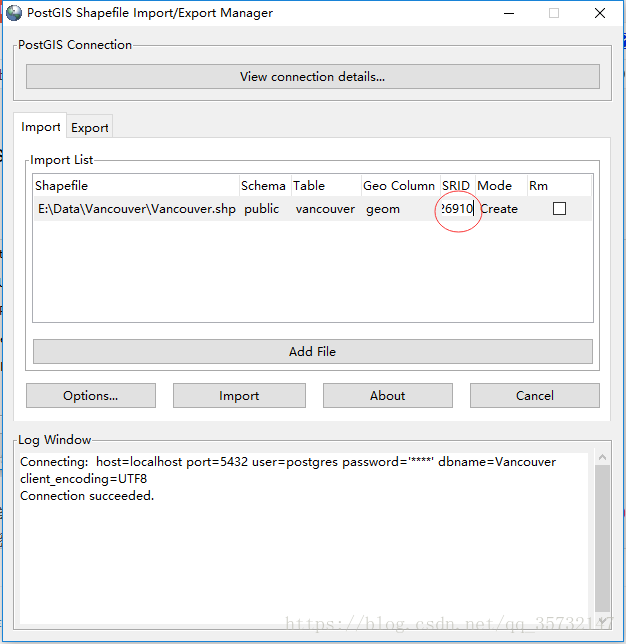
打开位于“开始>所有程序>PostGIS 2.3 bundle for PostgreSQL”之中的PostGIS Shapefile Import/Export Manager。
首先单击"View connection details"按钮,打开"PostGIS connection"对话框,输入用户名"postgres"及其对应的密码,设置连接的数据库,如下图所示:

连接数据库之后,单击"Add file"按钮,加入***.shp文件,并将其SRID设置为"4326",如下图所示。这一步绝对不能省略,否则不能正确导入数据。
5.河流数据拓扑处理
在数据分析过程中,使用到了pgrouting扩展中的 pgr_dijkstra 算法
Dijkstra算法(迪杰斯特拉算法),由荷兰计算机科学家Edsger Dijkstra于1956年提出。它是一种图搜索算法,它解决了非负代价边路径图的最短路径问题,即从起始顶点(start_vid)到结束顶点(end_vid)的最短路径。此算法可以与有向图或无向图一起使用。
函数的签名摘要:
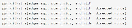
在实际使用中,需要先明确所有的顶点,并为所有顶点分配唯一的编号,函数的 start_vid 和 end_vid 都是整型数值,函数使用edges_sql参数(sql脚本)筛选出和顶点相邻的所有边信息(即河流信息)。
所以,在使用pgr_dijkstra方法前,需要
- 对找到河流的所有顶点信息,并做唯一整型值编号
- 在数据库中为每条河流设置好起始顶点和结束顶点
--筛选出所有顶点信息,st_dump函数主要是将MultiLineString类型 调整成 LineString类型

select  st_astext(st_startpoint((ST_Dump(geom)).geom)) from singleriver

union

select  st_astext(st_endpoint((ST_Dump(geom)).geom)) from singleriver
将查询结果在Excel中进行整型值编号,再导入到postgresql中的新建表 distinctpoint 中,然后关联河流数据表,更新河流的开始顶点(source)和结束顶点编号(target)
--更新起始顶点编号

update singleriver q

set source=tt.sourcepoint

from singleriver s,

(select gid,p.id as sourcepoint from

(select gid,st_astext(st_startpoint((ST_Dump(geom)).geom)) as startpoint, st_astext(st_endpoint((ST_Dump(geom)).geom)) as endpoint from singleriver )s

left join distinctpoint p

on s.startpoint=p.point) tt

where q.gid=tt.gid
--插入结束顶点编号

update singleriver q

set target=tt.endpoint

from singleriver s,

(select gid,p.id as endpoint from

(select gid,st_astext(st_startpoint((ST_Dump(geom)).geom)) as startpoint, st_astext(st_endpoint((ST_Dump(geom)).geom)) as endpoint from singleriver )s

left join distinctpoint p

on s.endpoint=p.point) tt

where q.gid=tt.gid
至此,河流拓扑数据处理完成
PG分析处理函数
1.函数编写
CREATE OR REPLACE FUNCTION "public"."pgr_shortest_river"(IN "startx" float8, IN "starty" float8, IN "endx" float8, IN "endy" float8, OUT "river_name" varchar, OUT "v_shpath" varchar, OUT "cost" float8)

  RETURNS SETOF "pg_catalog"."record" AS $BODY$

declare

v_startLine geometry;--离起点最近的线

v_endLine geometry;--离终点最近的线

v_startTarget integer;--距离起点最近线的终点

v_endSource integer;--距离终点最近线的起点

v_statpoint geometry;--在v_startLine上距离起点最近的点

v_endpoint geometry;--在v_endLine上距离终点最近的点

v_res geometry;--最短路径分析结果

v_perStart float;--v_statpoint在v_res上的百分比

v_perEnd float;--v_endpoint在v_res上的百分比

v_rec record;

first_name varchar;

end_name varchar;

first_cost double precision;

end_cost double precision;

begin

--查询离起点最近的线

execute 'select (st_dump(geom)).geom as geom,target as target,name from singleriver where

ST_DWithin(geom,ST_Geometryfromtext(''point('|| startx ||' ' || starty||')''),0.01)

order by ST_Distance(geom,ST_GeometryFromText(''point('|| startx ||' '|| starty ||')'')) limit 1'

into v_startLine ,v_startTarget,first_name;

raise notice '起点线段%',v_startLine;

raise notice '起点位置%',v_startTarget;

raise notice '河流名称%',first_name;

--查询离终点最近的线

execute 'select (st_dump(geom)).geom as geom,"source" as source,name from singleriver

where ST_DWithin(geom,ST_Geometryfromtext(''point('|| endx || ' ' || endy ||')''),0.01)

order by ST_Distance(geom,ST_GeometryFromText(''point('|| endx ||' ' || endy ||')'')) limit 1'

into v_endLine,v_endSource,end_name;

--如果没找到最近的线,就返回null

if (v_startLine is null) or (v_endLine is null) then

return;

end if ;

select ST_ClosestPoint(v_startLine, ST_Geometryfromtext('point('|| startx ||' ' || starty ||')')) into v_statpoint;

select ST_ClosestPoint(v_endLine, ST_GeometryFromText('point('|| endx ||' ' || endy ||')')) into v_endpoint;

--计算距离起点最近线上的点在该线中的位置

select st_linelocatepoint(st_linemerge(v_startLine), v_statpoint) into v_perStart;

select st_linelocatepoint(st_linemerge(v_endLine), v_endpoint) into v_perEnd;

select st_distancesphere(v_statpoint,ST_PointN(ST_GeometryN(v_startLine,1), ST_NumPoints(ST_GeometryN(v_startLine,1)))) into first_cost;

select st_distancesphere(ST_PointN(ST_GeometryN(v_endLine,1),1),v_endpoint) into end_cost;

if (ST_Intersects(st_geomfromtext('point('|| startx ||' '|| starty ||') '), v_startLine) and ST_Intersects(st_geomfromtext('point('|| endx ||' '|| endy ||') '), v_startLine)) then

select st_distancesphere(v_statpoint, v_endpoint) into first_cost;

select st_linelocatepoint(st_linemerge(v_startLine), v_endpoint) into v_perEnd;

for v_rec in

select st_linesubstring(st_linemerge(v_startLine), v_perStart,v_perEnd) as point,COALESCE(end_name,'无名河流') as name,end_cost as cost loop

v_shPath:= ST_AsGeoJSON(v_rec.point);

cost:= v_rec.cost;

river_name:= v_rec.name;

return next;

end loop;

return;

end if;

--最短路径

for v_rec in

(select st_linesubstring(st_linemerge(v_startLine),v_perStart,1) as point,COALESCE(first_name,'无名河流') as name,first_cost as cost

union all

SELECT st_linemerge(b.geom) as point,COALESCE(b.name,'无名河流') as name,st_length(geom, false) as cost

FROM pgr_dijkstra(

'SELECT gid as id, source, target, st_length(geom, false) as cost FROM singleriver

where st_intersects(geom,st_buffer(st_linefromtext(''linestring('||startx||' ' || starty ||','|| endx ||' ' || endy ||')''),0.05))',

v_startTarget, v_endSource , false

) a, singleriver b

WHERE a.edge = b.gid

union all

select st_linesubstring(st_linemerge(v_endLine),0,v_perEnd) as point,COALESCE(end_name,'无名河流') as name,end_cost as cost)

loop

v_shPath:= ST_AsGeoJSON(v_rec.point);

cost:= v_rec.cost;

river_name:= v_rec.name;

return next;

end loop;

end;

$BODY$

  LANGUAGE plpgsql VOLATILE STRICT

  COST 100

  ROWS 1000
2.参数说明
输入参数:开始点和结束点的经纬度坐标
输出结果:river_name:河流名称;v_shppath:流经的河流路径; cost:河流流经长度
3.内部调用函数说明
函数调用过程,根据postgis不同版本,函数名称可能会有偏差,有版本展示形式为 st_linesubstring ,有版本展示形式为 st_line_substring
4.输出结果验证
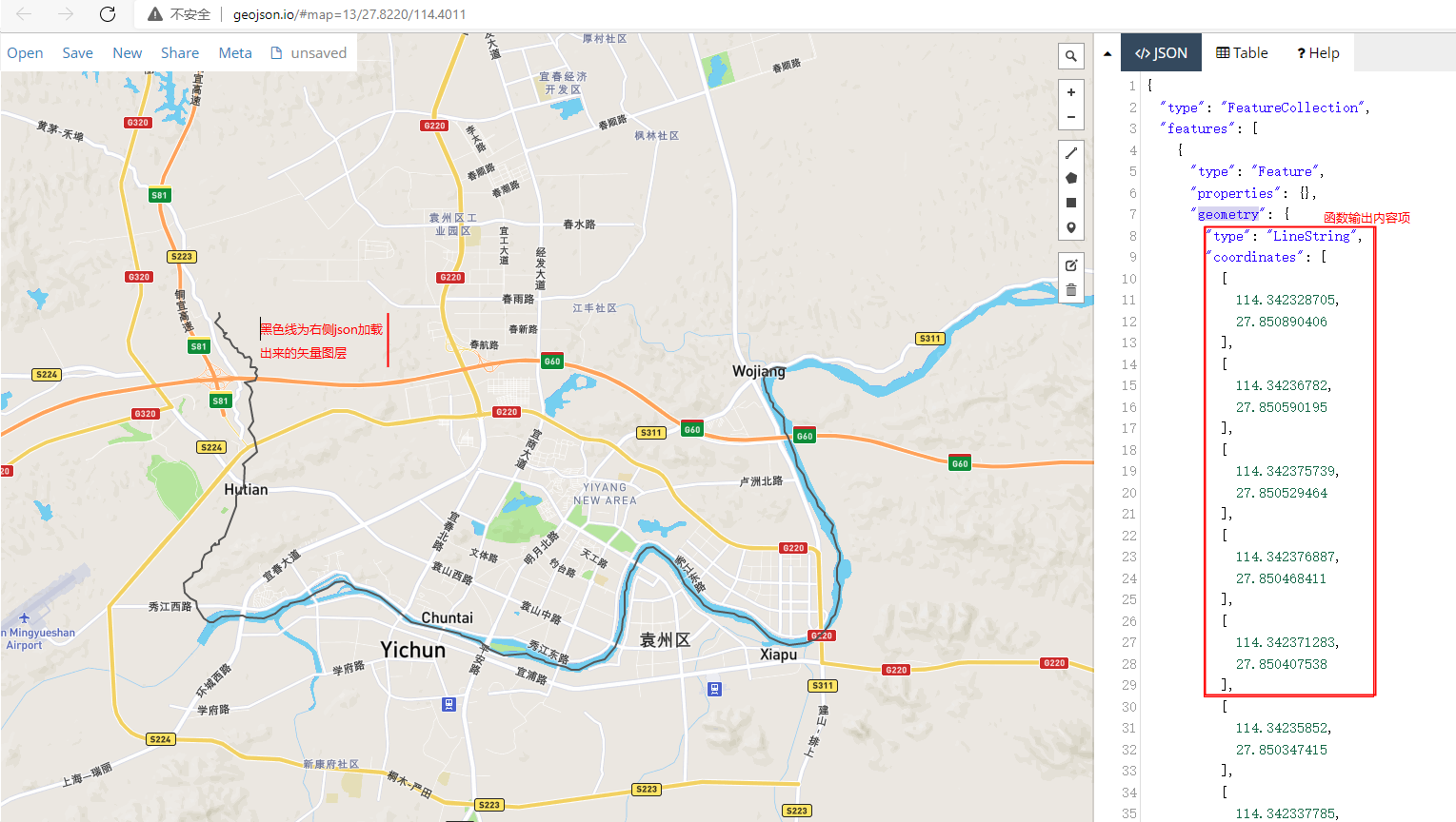
为了验证河流输出结果是否正确,流经河流路径是否连通,可以通过在线geojson地图(geojson.io)呈现出来验证。
在右侧json-features-geometry 中填充函数输出的v_shppath参数内容(按照行单独输入,可以输入多个,注意需要增加json属性)
使用PostGIS完成两点间的河流轨迹及流经长度的计算的更多相关文章
- 经纬度计算两点间的距离,根据距离排序SQL
#java的Utilspublic class DistanceUtil { // 地球平均半径 private static final double EARTH_RADIUS = 6378137; ...
- 利用百度API(JavaScript 版)实现在地图上绘制任一多边形,并判断给定经纬度是否在多边形范围内。以及两点间的测距功能
权声明:本文为博主原创文章,未经博主允许不得转载. 利用百度API(JavaScript 版)实现在地图上绘制任一多边形,并判断给定经纬度是否在多边形范围内.以及两点间的测距功能. 绘制多边形(蓝色) ...
- 用 Excel 测试“绘制两点间连线”的算法
最近在研究和制作数字示波器,其中涉及一个小算法:需要将 ADC 采样的数值在 TFT LCD 屏幕上面显示并且用“线”连接起来. ADC 按照时序对输入电压采样后,记录的是一个个的数值,如果显示的时候 ...
- 图算法之Floyd-Warshall 算法-- 任意两点间最小距离
1.Floyd-Warshall 算法 给定一张图,在o(n3)时间内求出任意两点间的最小距离,并可以在求解过程中保存路径 2.Floyd-Warshall 算法概念 这是一个动态规划的算法. 将顶点 ...
- HDOJ2001计算两点间的距离
计算两点间的距离 Time Limit: 2000/1000 MS (Java/Others) Memory Limit: 65536/32768 K (Java/Others)Total Su ...
- J - 计算两点间的距离
Time Limit:1000MS Memory Limit:32768KB 64bit IO Format:%I64d & %I64u Description 输入两 ...
- boost dijkstra获得两点间的最短路
需求是只需要得到两点间的最短路,不需要求得单源对于全图的最短路,使用boost中的dijsktra_shortest_path,当得到目标点的最短路时直接throw exception. #inclu ...
- 计算两点间的距离-hdu2001
Problem Description 输入两点坐标(X1,Y1),(X2,Y2),计算并输出两点间的距离. Input 输入数据有多组,每组占一行,由4个实数组成,分别表示x1,y1,x2,y2 ...
- 计算两点间的距离,hdu-2001
计算两点间的距离 Problem Description 输入两点坐标(X1,Y1),(X2,Y2),计算并输出两点间的距离. Input 输入数据有多组,每组占一行,由4个实数组成,分别表示x1 ...
随机推荐
- AtCoder Beginner Contest 169 题解
AtCoder Beginner Contest 169 题解 这场比赛比较简单,证明我没有咕咕咕的时候到了! A - Multiplication 1 没什么好说的,直接读入两个数输出乘积就好了. ...
- jQuery实现页面导航内容定位效果,并支持内容切换
需求 页面向下滚动时,需要将顶部的搜索栏信息和导航菜单吸顶,并且,搜索栏信息和导航菜单之间可以切换. 效果 https://www.iguopin.com/index.php?m=&c=ind ...
- Centos使用kafka自带zookeeper安装kafka
首先要安装jdk环境 可以参考:https://www.cnblogs.com/pxblog/p/10512886.html 下载kafka 地址:http://kafka.apache.org/do ...
- JAVA生成订单编号工具类
JAVA根据时间戳和随机数方式生成订单编号工具类 OrderUtils.java package com.util; import java.text.DateFormat; import java. ...
- 【LeetCode】1101. The Earliest Moment When Everyone Become Friends 解题报告 (C++)
作者: 负雪明烛 id: fuxuemingzhu 个人博客:http://fuxuemingzhu.cn/ 目录 题目描述 题目大意 解题方法 并查集 日期 题目地址:https://leetcod ...
- 【LeetCode】547. Friend Circles 解题报告(Python & Java & C++)
作者: 负雪明烛 id: fuxuemingzhu 个人博客: http://fuxuemingzhu.cn/ 目录 题目描述 题目大意 解题方法 日期 题目地址:https://leetcode.c ...
- 【LeetCode】838. Push Dominoes 解题报告(Python)
[LeetCode]838. Push Dominoes 解题报告(Python) 标签(空格分隔): LeetCode 作者: 负雪明烛 id: fuxuemingzhu 个人博客: http:// ...
- 【LeetCode】436. Find Right Interval 解题报告(Python)
[LeetCode]436. Find Right Interval 解题报告(Python) 标签(空格分隔): LeetCode 作者: 负雪明烛 id: fuxuemingzhu 个人博客: h ...
- uniapp中使用animate.css4.1.1动画库在小程序中不生效解决办法
找到源码animate.css修改以下代码 :root { --animate-duration: 1s; --animate-delay: 1s; --animate-repeat: 1; } // ...
- Java基础(八)——IO流2_缓冲流、转换流
一.缓冲流 1.介绍 缓冲流:不能直接作用在文件上,需要包一层,它是一种处理流.用于提高文件的读写效率.它在流的基础上对流的功能进行了增强.提高读写速度的原因:内部提供了一个缓冲区.缺省使用 8192 ...