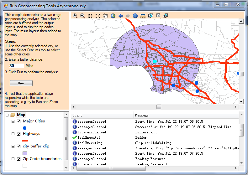
AE开发示例之RunGPAsync
using System;
using System.Collections.Generic;
using System.ComponentModel;
using System.Data;
using System.Drawing;
using System.Text;
using System.Windows.Forms;
using ESRI.ArcGIS.esriSystem;
using ESRI.ArcGIS.Carto;
using ESRI.ArcGIS.Controls;
using ESRI.ArcGIS.SystemUI;
using ESRI.ArcGIS.Display;
using ESRI.ArcGIS.Geometry;
using ESRI.ArcGIS.Geodatabase;
using ESRI.ArcGIS.Geoprocessor;
using ESRI.ArcGIS.Geoprocessing;
using ESRI.ArcGIS.DataManagementTools;
namespace RunGPAsync
{
public partial class RunGPForm : Form
{
private Geoprocessor _gp = null;
private Dictionary<string, IFeatureLayer> _layersDict = new Dictionary<string, IFeatureLayer>();
private List<IFeatureLayer> _resultsList = new List<IFeatureLayer>();
private Queue<IGPProcess> _myGPToolsToExecute = new Queue<IGPProcess>();
public RunGPForm()
{
InitializeComponent();
listView1.Columns.Add("Event", 200, HorizontalAlignment.Left);
listView1.Columns.Add("Message", 1000, HorizontalAlignment.Left);
listView1.SmallImageList = imageList1;
_gp = new Geoprocessor();
string outputDir = System.Environment.GetEnvironmentVariable("TEMP");
_gp.SetEnvironmentValue("workspace", outputDir);
_gp.OverwriteOutput = true;
_gp.ToolExecuted += new EventHandler<ToolExecutedEventArgs>(_gp_ToolExecuted);
_gp.ProgressChanged += new EventHandler<ESRI.ArcGIS.Geoprocessor.ProgressChangedEventArgs>(_gp_ProgressChanged);
_gp.MessagesCreated += new EventHandler<MessagesCreatedEventArgs>(_gp_MessagesCreated);
_gp.ToolExecuting += new EventHandler<ToolExecutingEventArgs>(_gp_ToolExecuting);
SetupMap();
}
private void btnRunGP_Click(object sender, EventArgs e)
{
try
{
listView1.Items.Clear();
IMapLayers mapLayers = axMapControl1.Map as IMapLayers;
foreach (IFeatureLayer resultLayer in _resultsList)
{
mapLayers.DeleteLayer(resultLayer);
}
axTOCControl1.Update();
_resultsList.Clear();
_myGPToolsToExecute.Clear();
ESRI.ArcGIS.AnalysisTools.Buffer bufferTool = new ESRI.ArcGIS.AnalysisTools.Buffer();
bufferTool.in_features = _layersDict["Cities"];
bufferTool.buffer_distance_or_field = txtBufferDistance.Text + " Miles";
bufferTool.out_feature_class = "city_buffer.shp";
ESRI.ArcGIS.AnalysisTools.Clip clipTool = new ESRI.ArcGIS.AnalysisTools.Clip();
clipTool.in_features = _layersDict["ZipCodes"];
clipTool.clip_features = bufferTool.out_feature_class;
clipTool.out_feature_class = "city_buffer_clip.shp";
_myGPToolsToExecute.Enqueue(bufferTool);
_myGPToolsToExecute.Enqueue(clipTool);
_gp.ExecuteAsync(_myGPToolsToExecute.Dequeue());
}
catch (Exception ex)
{
listView1.Items.Add(new ListViewItem(new string[2] { "N/A", ex.Message }, "error"));
}
}
void _gp_ProgressChanged(object sender, ESRI.ArcGIS.Geoprocessor.ProgressChangedEventArgs e)
{
IGeoProcessorResult2 gpResult = (IGeoProcessorResult2)e.GPResult;
if (e.ProgressChangedType == ProgressChangedType.Message)
{
listView1.Items.Add(new ListViewItem(new string[2] {"ProgressChanged", e.Message}, "information"));
}
}
void _gp_ToolExecuting(object sender, ToolExecutingEventArgs e)
{
IGeoProcessorResult2 gpResult = (IGeoProcessorResult2)e.GPResult;
listView1.Items.Add(new ListViewItem(new string[2] { "ToolExecuting", gpResult.Process.Tool.Name + " " + gpResult.Status.ToString() }, "information"));
}
void _gp_ToolExecuted(object sender, ToolExecutedEventArgs e)
{
IGeoProcessorResult2 gpResult = (IGeoProcessorResult2)e.GPResult;
try
{
if (gpResult.Status == esriJobStatus.esriJobSucceeded)
{
listView1.Items.Add(new ListViewItem(new string[2] { "ToolExecuted", gpResult.Process.Tool.Name }, "success"));
if (_myGPToolsToExecute.Count > 0)
{
_gp.ExecuteAsync(_myGPToolsToExecute.Dequeue());
}
else
{
IFeatureClass resultFClass = _gp.Open(gpResult.ReturnValue) as IFeatureClass;
IFeatureLayer resultLayer = new FeatureLayerClass();
resultLayer.FeatureClass = resultFClass;
resultLayer.Name = resultFClass.AliasName;
axMapControl1.AddLayer((ILayer)resultLayer, 2);
axTOCControl1.Update();
_resultsList.Add(resultLayer);
}
}
else if (gpResult.Status == esriJobStatus.esriJobFailed)
{
listView1.Items.Add(new ListViewItem(new string[2] { "ToolExecuted", gpResult.Process.Tool.Name + " failed, any remaining processes will not be executed." }, "error"));
_myGPToolsToExecute.Clear();
}
}
catch (Exception ex)
{
listView1.Items.Add(new ListViewItem(new string[2] { "ToolExecuted", ex.Message }, "error"));
}
}
/// <summary>
/// Handles the MessagesCreated event.
/// </summary>
void _gp_MessagesCreated(object sender, MessagesCreatedEventArgs e)
{
IGPMessages gpMsgs = e.GPMessages;
if (gpMsgs.Count > 0)
{
for (int count = 0; count < gpMsgs.Count; count++)
{
IGPMessage msg = gpMsgs.GetMessage(count);
string imageToShow = "information";
switch (msg.Type)
{
case esriGPMessageType.esriGPMessageTypeAbort:
imageToShow = "warning";
break;
case esriGPMessageType.esriGPMessageTypeEmpty:
imageToShow = "information";
break;
case esriGPMessageType.esriGPMessageTypeError:
imageToShow = "error";
break;
case esriGPMessageType.esriGPMessageTypeGDBError:
imageToShow = "error";
break;
case esriGPMessageType.esriGPMessageTypeInformative:
imageToShow = "information";
break;
case esriGPMessageType.esriGPMessageTypeProcessDefinition:
imageToShow = "information";
break;
case esriGPMessageType.esriGPMessageTypeProcessStart:
imageToShow = "information";
break;
case esriGPMessageType.esriGPMessageTypeProcessStop:
imageToShow = "information";
break;
case esriGPMessageType.esriGPMessageTypeWarning:
imageToShow = "warning";
break;
default:
break;
}
listView1.Items.Add(new ListViewItem(new string[2]{"MessagesCreated", msg.Description}, imageToShow));
}
}
}
#region Helper methods for setting up map and layers and validating buffer distance input
/// <summary>
/// Loads and symbolizes data used by the application. Selects a city and zooms to it
/// </summary>
private void SetupMap()
{
try
{
//Relative path to the sample data from EXE location
string dirPath = @"..\..\..\..\..\data\USZipCodeData";
//Create the cities layer
IFeatureClass cities = _gp.Open(dirPath + @"\ZipCode_Boundaries_US_Major_Cities.shp") as IFeatureClass;
IFeatureLayer citiesLayer = new FeatureLayerClass();
citiesLayer.FeatureClass = cities;
citiesLayer.Name = "Major Cities";
//Create he zip code boundaries layer
IFeatureClass zipBndrys = _gp.Open(dirPath + @"\US_ZipCodes.shp") as IFeatureClass;
IFeatureLayer zipBndrysLayer = new FeatureLayerClass();
zipBndrysLayer.FeatureClass = zipBndrys;
zipBndrysLayer.Name = "Zip Code boundaries";
//Create the highways layer
dirPath = @"..\..\..\..\..\data\USAMajorHighways";
IFeatureClass highways = _gp.Open(dirPath + @"\usa_major_highways.shp") as IFeatureClass;
IFeatureLayer highwaysLayer = new FeatureLayerClass();
highwaysLayer.FeatureClass = highways;
highwaysLayer.Name = "Highways";
//***** Important code *********
//Add the layers to a dictionary. Layers can then easily be returned by their 'key'
_layersDict.Add("ZipCodes", zipBndrysLayer);
_layersDict.Add("Highways", highwaysLayer);
_layersDict.Add("Cities", citiesLayer);
#region Symbolize and set additional properties for each layer
//Setup and symbolize the cities layer
citiesLayer.Selectable = true;
citiesLayer.ShowTips = true;
ISimpleMarkerSymbol markerSym = CreateSimpleMarkerSymbol(CreateRGBColor(0, 92, 230), esriSimpleMarkerStyle.esriSMSCircle);
markerSym.Size = 9;
ISimpleRenderer simpleRend = new SimpleRendererClass();
simpleRend.Symbol = (ISymbol)markerSym;
((IGeoFeatureLayer)citiesLayer).Renderer = (IFeatureRenderer)simpleRend;
//Setup and symbolize the zip boundaries layer
zipBndrysLayer.Selectable = false;
ISimpleFillSymbol fillSym = CreateSimpleFillSymbol(CreateRGBColor(0, 0, 0), esriSimpleFillStyle.esriSFSHollow, CreateRGBColor(204, 204, 204), esriSimpleLineStyle.esriSLSSolid, 0.5);
ISimpleRenderer simpleRend2 = new SimpleRendererClass();
simpleRend2.Symbol = (ISymbol)fillSym;
((IGeoFeatureLayer)zipBndrysLayer).Renderer = (IFeatureRenderer)simpleRend2;
//Setup and symbolize the highways layer
highwaysLayer.Selectable = false;
ISimpleLineSymbol lineSym = CreateSimpleLineSymbol(CreateRGBColor(250, 52, 17), 3.4, esriSimpleLineStyle.esriSLSSolid);
ISimpleRenderer simpleRend3 = new SimpleRendererClass();
simpleRend3.Symbol = (ISymbol)lineSym;
((IGeoFeatureLayer)highwaysLayer).Renderer = (IFeatureRenderer)simpleRend3;
#endregion
//Add the layers to the Map
foreach (IFeatureLayer layer in _layersDict.Values)
{
axMapControl1.AddLayer((ILayer)layer);
}
#region select city and set map extent
//Select and zoom in on Los Angeles city
IQueryFilter qf = new QueryFilterClass();
qf.WhereClause = "NAME='Los Angeles'";
IFeatureSelection citiesLayerSelection = (IFeatureSelection)citiesLayer;
citiesLayerSelection.SelectFeatures(qf, esriSelectionResultEnum.esriSelectionResultNew, true);
IFeature laFeature = cities.GetFeature(citiesLayerSelection.SelectionSet.IDs.Next());
IEnvelope env = laFeature.Shape.Envelope;
env.Expand(0.5, 0.5, false);
axMapControl1.Extent = env;
axMapControl1.Refresh();
axTOCControl1.Update();
#endregion
//Enable GP analysis button
btnRunGP.Enabled = true;
}
catch (Exception ex)
{
MessageBox.Show("There was an error loading the data used by this sample: " + ex.Message);
}
}
#region"Create Simple Fill Symbol"
// ArcGIS Snippet Title:
// Create Simple Fill Symbol
//
// Long Description:
// Create a simple fill symbol by specifying a color, outline color and fill style.
//
// Add the following references to the project:
// ESRI.ArcGIS.Display
// ESRI.ArcGIS.System
//
// Intended ArcGIS Products for this snippet:
// ArcGIS Desktop (ArcEditor, ArcInfo, ArcView)
// ArcGIS Engine
// ArcGIS Server
//
// Applicable ArcGIS Product Versions:
// 9.2
// 9.3
// 9.3.1
// 10.0
//
// Required ArcGIS Extensions:
// (NONE)
//
// Notes:
// This snippet is intended to be inserted at the base level of a Class.
// It is not intended to be nested within an existing Method.
//
///<summary>Create a simple fill symbol by specifying a color, outline color and fill style.</summary>
///
///<param name="fillColor">An IRGBColor interface. The color for the inside of the fill symbol.</param>
///<param name="fillStyle">An esriSimpleLineStyle enumeration for the inside fill symbol. Example: esriSFSSolid.</param>
///<param name="borderColor">An IRGBColor interface. The color for the outside line border of the fill symbol.</param>
///<param name="borderStyle">An esriSimpleLineStyle enumeration for the outside line border. Example: esriSLSSolid.</param>
///<param name="borderWidth">A System.Double that is the width of the outside line border in points. Example: 2</param>
///
///<returns>An ISimpleFillSymbol interface.</returns>
///
///<remarks></remarks>
public ESRI.ArcGIS.Display.ISimpleFillSymbol CreateSimpleFillSymbol(ESRI.ArcGIS.Display.IRgbColor fillColor, ESRI.ArcGIS.Display.esriSimpleFillStyle fillStyle, ESRI.ArcGIS.Display.IRgbColor borderColor, ESRI.ArcGIS.Display.esriSimpleLineStyle borderStyle, System.Double borderWidth)
{
ESRI.ArcGIS.Display.ISimpleLineSymbol simpleLineSymbol = new ESRI.ArcGIS.Display.SimpleLineSymbolClass();
simpleLineSymbol.Width = borderWidth;
simpleLineSymbol.Color = borderColor;
simpleLineSymbol.Style = borderStyle;
ESRI.ArcGIS.Display.ISimpleFillSymbol simpleFillSymbol = new ESRI.ArcGIS.Display.SimpleFillSymbolClass();
simpleFillSymbol.Outline = simpleLineSymbol;
simpleFillSymbol.Style = fillStyle;
simpleFillSymbol.Color = fillColor;
return simpleFillSymbol;
}
#endregion
#region"Create Simple Line Symbol"
// ArcGIS Snippet Title:
// Create Simple Line Symbol
//
// Long Description:
// Create a simple line symbol by specifying a color, width and line style.
//
// Add the following references to the project:
// ESRI.ArcGIS.Display
// ESRI.ArcGIS.System
//
// Intended ArcGIS Products for this snippet:
// ArcGIS Desktop (ArcEditor, ArcInfo, ArcView)
// ArcGIS Engine
// ArcGIS Server
//
// Applicable ArcGIS Product Versions:
// 9.2
// 9.3
// 9.3.1
// 10.0
//
// Required ArcGIS Extensions:
// (NONE)
//
// Notes:
// This snippet is intended to be inserted at the base level of a Class.
// It is not intended to be nested within an existing Method.
//
///<summary>Create a simple line symbol by specifying a color, width and line style.</summary>
///
///<param name="rgbColor">An IRGBColor interface.</param>
///<param name="inWidth">A System.Double that is the width of the line symbol in points. Example: 2</param>
///<param name="inStyle">An esriSimpleLineStyle enumeration. Example: esriSLSSolid.</param>
///
///<returns>An ISimpleLineSymbol interface.</returns>
///
///<remarks></remarks>
public ESRI.ArcGIS.Display.ISimpleLineSymbol CreateSimpleLineSymbol(ESRI.ArcGIS.Display.IRgbColor rgbColor, System.Double inWidth, ESRI.ArcGIS.Display.esriSimpleLineStyle inStyle)
{
if (rgbColor == null)
{
return null;
}
ESRI.ArcGIS.Display.ISimpleLineSymbol simpleLineSymbol = new ESRI.ArcGIS.Display.SimpleLineSymbolClass();
simpleLineSymbol.Style = inStyle;
simpleLineSymbol.Color = rgbColor;
simpleLineSymbol.Width = inWidth;
return simpleLineSymbol;
}
#endregion
#region"Create Simple Marker Symbol"
// ArcGIS Snippet Title:
// Create Simple Marker Symbol
//
// Long Description:
// Create a simple marker symbol by specifying and input color and marker style.
//
// Add the following references to the project:
// ESRI.ArcGIS.Display
// ESRI.ArcGIS.System
//
// Intended ArcGIS Products for this snippet:
// ArcGIS Desktop (ArcEditor, ArcInfo, ArcView)
// ArcGIS Engine
// ArcGIS Server
//
// Applicable ArcGIS Product Versions:
// 9.2
// 9.3
// 9.3.1
// 10.0
//
// Required ArcGIS Extensions:
// (NONE)
//
// Notes:
// This snippet is intended to be inserted at the base level of a Class.
// It is not intended to be nested within an existing Method.
//
///<summary>Create a simple marker symbol by specifying and input color and marker style.</summary>
///
///<param name="rgbColor">An IRGBColor interface.</param>
///<param name="inputStyle">An esriSimpleMarkerStyle enumeration. Example: esriSMSCircle.</param>
///
///<returns>An ISimpleMarkerSymbol interface.</returns>
///
///<remarks></remarks>
public ESRI.ArcGIS.Display.ISimpleMarkerSymbol CreateSimpleMarkerSymbol(ESRI.ArcGIS.Display.IRgbColor rgbColor, ESRI.ArcGIS.Display.esriSimpleMarkerStyle inputStyle)
{
ESRI.ArcGIS.Display.ISimpleMarkerSymbol simpleMarkerSymbol = new ESRI.ArcGIS.Display.SimpleMarkerSymbolClass();
simpleMarkerSymbol.Color = rgbColor;
simpleMarkerSymbol.Style = inputStyle;
return simpleMarkerSymbol;
}
#endregion
#region"Create RGBColor"
// ArcGIS Snippet Title:
// Create RGBColor
//
// Long Description:
// Generate an RgbColor by specifying the amount of Red, Green and Blue.
//
// Add the following references to the project:
// ESRI.ArcGIS.Display
// ESRI.ArcGIS.System
//
// Intended ArcGIS Products for this snippet:
// ArcGIS Desktop (ArcEditor, ArcInfo, ArcView)
// ArcGIS Engine
// ArcGIS Server
//
// Applicable ArcGIS Product Versions:
// 9.2
// 9.3
// 9.3.1
// 10.0
//
// Required ArcGIS Extensions:
// (NONE)
//
// Notes:
// This snippet is intended to be inserted at the base level of a Class.
// It is not intended to be nested within an existing Method.
//
///<summary>Generate an RgbColor by specifying the amount of Red, Green and Blue.</summary>
///
///<param name="myRed">A byte (0 to 255) used to represent the Red color. Example: 0</param>
///<param name="myGreen">A byte (0 to 255) used to represent the Green color. Example: 255</param>
///<param name="myBlue">A byte (0 to 255) used to represent the Blue color. Example: 123</param>
///
///<returns>An IRgbColor interface</returns>
///
///<remarks></remarks>
public ESRI.ArcGIS.Display.IRgbColor CreateRGBColor(System.Byte myRed, System.Byte myGreen, System.Byte myBlue)
{
ESRI.ArcGIS.Display.IRgbColor rgbColor = new ESRI.ArcGIS.Display.RgbColorClass();
rgbColor.Red = myRed;
rgbColor.Green = myGreen;
rgbColor.Blue = myBlue;
rgbColor.UseWindowsDithering = true;
return rgbColor;
}
#endregion
private void txtBufferDistance_TextChanged(object sender, EventArgs e)
{
string txtToCheck = txtBufferDistance.Text;
if (((IsDecimal(txtToCheck)) | (IsInteger(txtToCheck))) && (txtToCheck != "0"))
{
btnRunGP.Enabled = true;
}
else
{
btnRunGP.Enabled = false;
}
}
private bool IsDecimal(string theValue)
{
try
{
Convert.ToDouble(theValue);
return true;
}
catch
{
return false;
}
} //IsDecimal
private bool IsInteger(string theValue)
{
try
{
Convert.ToInt32(theValue);
return true;
}
catch
{
return false;
}
} //IsInteger
#endregion
}
}
AE开发示例之RunGPAsync的更多相关文章
- AE开发示例之GPBufferLayer
using System; using System.Drawing;using System.Text;using System.Windows.Forms;using System.Runtime ...
- Github团队开发示例(二)
Github团队开发示例(二) 作者:Grey 原文地址:http://www.cnblogs.com/greyzeng/p/6063765.html 接之前讲的Github团队开发示例(一),本文主 ...
- Github团队开发示例(一)
Github团队开发示例(二) 作者:Grey 原文地址:http://www.cnblogs.com/greyzeng/p/6044837.html 我们可以在Github上管理自己的团队项目.团队 ...
- AE开发使用内存图层
AE开发中,有时需要从磁盘中读取一些文件信息如坐标点转为图层并进行分析,此过程并不需要坐标点入库之类的操作,就可以创建一个内存图层解决问题.创建内存图层需要用到InMemoryWorkspaceFac ...
- AE开发能否实现TOC Control里添加多个Data Frame
问题: 在ArcMap中,菜单Insert下Data Frame,可以在TOC中增加Data Frame,在MapControl或者PageLayoutControl下都可以正常显示多个Data Fr ...
- DevExpress .NET界面开发示例大全
说到做.net界面开发,很多人应该都会想到DevExpress. 它的 .net界面开发系列一共有7个版本:WinForms.ASP.NET.MVC.WPF.Silverlight.Windows 8 ...
- Padrino 博客开发示例
英文版出处:http://www.padrinorb.com/guides/blog-tutorial 楼主按 拿作者自己的话说:Padrino(谐音:派骓诺)是一款基于Sinatra的优雅的Web应 ...
- TWaver Flex开发示例及license下载
做电信项目的朋友一定知道TWaver,而Flex版具有很好的跨平台性,很适合做B/S模式的应用. Flex版的在线DEMO:http://twaver.servasoft.com/demo/twave ...
- NPAPI火狐插件VS2013开发示例
NPAPI火狐插件VS2013开发示例 下面是我根据网上开发示例自己做的一个demo,并提供代码下载. 开发环境 Windows 8.1 x64 Visual studio 2013 准备工作 首先需 ...
随机推荐
- 八皇后—Java
package queen; public class queen { static boolean col[] = new boolean[8]; static boolean main_diago ...
- div各种距离 详细解释图
详细博文介绍:http://blog.csdn.net/fswan/article/details/17238933
- 创建Maven web项目时 出现 web.xml is missing and <failOnMissingWebXml> is set to true错误 pox.xml编译错误
今天创建一个maven项目 pom.xml出现如下错误: web.xml is missing and <failOnMissingWebXml> is set to true 这是因为你 ...
- php部分---文件上传:错误处理、 客户端和服务器端的限制
1.客户端页面 <!---客户端的配置 1.表单页面 2.表单发送方式为post 3.表单form中添加enctype="multipart/form-data" ----- ...
- LeetCode() Symmetric Tree
/** * Definition for a binary tree node. * struct TreeNode { * int val; * TreeNode *left; * TreeNode ...
- [THINKING IN JAVA]复用类
7 复用类 7.1 组合 即在一个类中使用另一个类作为成员变量,这是复用了现有程序代码的功能,而非形式. 7.2 继承 关键字:extends,这种复用是形式的复用,是一种可扩展和限制的复用: 复用: ...
- mac电脑的使用
1. control + command + a 截图 2. shift + command + g 前往 3.在 Mac OS X 中怎样获取当前文件夹的路径 原文网址:https://www.zh ...
- Python之路,day9-Python基础
回顾:抽象方法@staticmethod 不能访问类的任何属性@classmethod 类方法 只能访问公有属性@property 属性方法 , 把一个方法变成一个静态属性def sayhi() pa ...
- Hue
Hue是一个开源的Apache Hadoop UI系统,由Cloudera Desktop演化而来,最后Cloudera公司将其贡献给Apache基金会的Hadoop社区,它是基于Python Web ...
- DevWebForm控件,触发用客户端事件
ClientInstanceName+".Raise"+"事件名", 例如: ClientInstanceName.RaiseValueChanged();