
ArcEngine 创建要素,删除要素,生成网格,渲染图层(VB)
示例代码:https://github.com/yu969890202/ArcEngine/tree/master/WinFrom_ArcEngine_PointDistribution
博客后面有两张图片,不懂得可以看看效果

Public Function CreateFeatureClass() As IFeatureClass

        Dim pWorkspaceFactory As IWorkspaceFactory = New ESRI.ArcGIS.DataSourcesGDB.AccessWorkspaceFactory

        Dim dataset As IDataset = pPointFeatureLayer.FeatureClass

        Dim featureWorkspace As IFeatureWorkspace = pWorkspaceFactory.OpenFromFile(dataset.Workspace.PathName, ) 'dataset.Workspace.PathName="C:\\aa.mdb"

        Dim workspace As IWorkspace2 = featureWorkspace

        Dim featureClassName As String = "New"

        Dim fields As IFields = Nothing

        Dim CLSID As ESRI.ArcGIS.esriSystem.UID = Nothing

        Dim CLSEXT As ESRI.ArcGIS.esriSystem.UID = Nothing

        Dim strConfigKeyword As String = ""

        Dim featureClass As IFeatureClass

        If workspace.NameExists(esriDatasetType.esriDTFeatureClass, featureClassName) Then '如果存在删除改要素

            featureClass = featureWorkspace.OpenFeatureClass(featureClassName)

            Dim pDataset As IDataset = featureClass

            pDataset.Delete() '删除该要素

        End If

        ' 赋值类ID如果未分配

        If CLSID Is Nothing Then

            CLSID = New ESRI.ArcGIS.esriSystem.UID

            CLSID.Value = "esriGeoDatabase.Feature"

        End If

        Dim objectClassDescription As IObjectClassDescription = New FeatureClassDescription

        If fields Is Nothing Then

            ' 创建字段

            fields = objectClassDescription.RequiredFields

            Dim fieldsEdit As IFieldsEdit = CType(fields, IFieldsEdit)

            Dim field As IField = New Field

            Dim fieldEdit As IFieldEdit = CType(field, IFieldEdit) ' 显示转换

            ' 设置字段属性

            fieldEdit.Name_2 = "SampleField"

            fieldEdit.Type_2 = esriFieldType.esriFieldTypeString

            fieldEdit.IsNullable_2 = True

            fieldEdit.AliasName_2 = "Sample Field Column"

            fieldEdit.DefaultValue_2 = "test"

            fieldEdit.Editable_2 = True

            fieldEdit.Length_2 =

            '添加到字段集中

            fieldsEdit.AddField(field)

            fields = CType(fieldsEdit, IFields)

        End If

        Dim strShapeField As String = ""

        Dim j As Int32

        For j =  To fields.FieldCount

            If fields.Field(j).Type = esriFieldType.esriFieldTypeGeometry Then

                strShapeField = fields.Field(j).Name

                Exit For

            End If

        Next j

        Dim fieldChecker As IFieldChecker = New FieldChecker

        Dim enumFieldError As IEnumFieldError = Nothing

        Dim validatedFields As IFields = Nothing

        fieldChecker.ValidateWorkspace = CType(workspace, IWorkspace)

        fieldChecker.Validate(fields, enumFieldError, validatedFields)

        featureClass = featureWorkspace.CreateFeatureClass(featureClassName, validatedFields, CLSID, CLSEXT, esriFeatureType.esriFTSimple, strShapeField, strConfigKeyword)

        '添加要素,跟据其他要素的范围,生成一个边长为length的矩形网格用于渲染

        Dim length As Integer =  '方块长度

        Dim pLineLayer As ILayer = pLineFeatureLayer

        Dim pEnvelope As IEnvelope = pLineLayer.AreaOfInterest

        Dim XMin As Double = pEnvelope.XMin

        Dim XMax As Double = pEnvelope.XMax

        Dim YMax As Double = pEnvelope.YMax

        Dim newXMin As Double = XMin + length

        Do While newXMin < XMax

            Dim YMin As Double = pEnvelope.YMin

            Dim newYMin As Double = YMin + length

            Do While newYMin < YMax

                AddFeature(XMin, newXMin, YMin, newYMin, featureClass.CreateFeature())

                YMin = newYMin

                newYMin = YMin + length

            Loop

            AddFeature(XMin, newXMin, YMin, newYMin, featureClass.CreateFeature())

            XMin = newXMin

            newXMin = XMin + length

        Loop

        Dim pNewFeatureLayer As IFeatureLayer = New FeatureLayer

        pNewFeatureLayer.FeatureClass = featureClass

        m_MapControl.AddLayer(pNewFeatureLayer, )

        m_MapControl.Refresh()

        MessageBox.Show("生成完毕")

    End Function
创建单个方格要素:
    Private Function AddFeature(ByVal XMin As Double, ByVal newXMin As Double, ByVal YMin As Double, ByVal newYMin As Double, ByVal pFeature As IFeature)

        Dim pPoint1 As IPoint = New Point()

        pPoint1.X = XMin

        pPoint1.Y = YMin

        Dim pPoint2 As IPoint = New Point()

        pPoint2.X = newXMin

        pPoint2.Y = YMin

        Dim pPoint3 As IPoint = New Point()

        pPoint3.X = newXMin

        pPoint3.Y = newYMin

        Dim pPoint4 As IPoint = New Point()

        pPoint4.X = XMin

        pPoint4.Y = newYMin

        Dim pPOlygon As IPolygon

        Dim pPointColec As IPointCollection = New Polygon

        pPointColec.AddPoint(pPoint1)

        pPointColec.AddPoint(pPoint2)

        pPointColec.AddPoint(pPoint3)

        pPointColec.AddPoint(pPoint4)

        pPOlygon = CType(pPointColec, IPolygon)

        pFeature.Shape = pPOlygon

        pFeature.Store()

    End Function
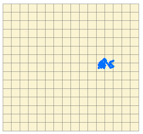
生成(黄色格网为生成图层)后如下图:
后面开始添加值和渲染图层:
通过空间查询,再生成方格(Featuer)时通过空间查询查询方格上面点的个数。
  Dim pSpatialFilter As ESRI.ArcGIS.Geodatabase.ISpatialFilter = New ESRI.ArcGIS.Geodatabase.SpatialFilter

        pSpatialFilter.Geometry = pPolygon

        pSpatialFilter.SpatialRel = esriSpatialRelEnum.esriSpatialRelIntersects '相交的状态

        Dim featureCursor As ESRI.ArcGIS.Geodatabase.IFeatureCursor = pPointFeatureLayer.FeatureClass.Search(pSpatialFilter, False)

        Dim count As Integer =

        Dim pTmpFeature = featureCursor.NextFeature()

        While Not IsNothing(pTmpFeature)

            count +=

            pTmpFeature = featureCursor.NextFeature()

        End While

        Dim fieldindex As Integer = pFeature.Fields.FindField("num")

        pFeature.Value(fieldindex) = count
然后通过生成的字段进行渐变渲染:
  Private Sub DefineUniqueValueRenderer(ByVal pGeoFeatureLayer As IGeoFeatureLayer, ByVal fieldName As String)

        '创建于渲染器的符号渐变颜色.

        Dim algColorRamp As IAlgorithmicColorRamp = New AlgorithmicColorRamp

        algColorRamp.FromColor = getRgbColor(, , ) '灰色

        algColorRamp.ToColor = getRgbColor(, , )

        algColorRamp.Algorithm = esriColorRampAlgorithm.esriCIELabAlgorithm

        Dim pUniqueValueRenderer As IUniqueValueRenderer = New UniqueValueRenderer()

        Dim pSimpleFillSymbol As ISimpleFillSymbol = New SimpleFillSymbol()

        pSimpleFillSymbol.Style = esriSimpleFillStyle.esriSFSSolid

        pSimpleFillSymbol.Outline.Width = 0.4

        '这些属性之前应增加值来设置.

    pUniqueValueRenderer.FieldCount =

    pUniqueValueRenderer.Field() = fieldName

    pUniqueValueRenderer.DefaultSymbol = pSimpleFillSymbol

    pUniqueValueRenderer.UseDefaultSymbol = False '不使用空值的黑色样式

    Dim pDisplayTable As IDisplayTable = pGeoFeatureLayer

    Dim i As Integer =

    Dim strsql As String = "SELECT distinct(num) FROM new order by num"

    Dim pDR As IDataReader = Nothing

    Try

      pDR = DBHelper.Create().ExecuteReader(strsql)

      While pDR.Read
       '每一个值都要生成一个新的样式,如果只创建一个样式对象的话,最后生成的效果会是一样的。

        Dim pClassSymbol As ISimpleFillSymbol = New SimpleFillSymbol()

        pClassSymbol.Style = esriSimpleFillStyle.esriSFSSolid

        pClassSymbol.Outline.Width = 0.4

        Dim classValue As Integer = CType(pDR.GetValue(), Integer)

        pUniqueValueRenderer.AddValue(classValue, fieldName, pClassSymbol)

          pUniqueValueRenderer.Label(classValue) = classValue

        pUniqueValueRenderer.Symbol(classValue) = pClassSymbol

        i +=

      End While

      pDR.Close()

      DBHelper.Create().CloseDBConnection()

    Catch ex As Exception

      If pDR IsNot Nothing Then pDR.Close()

      DBHelper.Create().CloseDBConnection()

    End Try

    algColorRamp.Size = pUniqueValueRenderer.ValueCount

    Dim bOK As Boolean

    algColorRamp.CreateRamp(bOK)

    Dim pEnumColors As IEnumColors = algColorRamp.Colors

    pEnumColors.Reset()

    Dim j As Integer

    For j =  To pUniqueValueRenderer.ValueCount -  Step j +

      Dim xv As String

      xv = pUniqueValueRenderer.Value(j)

      If xv <> "" Then

        Dim pSimpleFillColor As ISimpleFillSymbol = pUniqueValueRenderer.Symbol(xv)

        pSimpleFillColor.Color = pEnumColors.Next()

        pUniqueValueRenderer.Symbol(xv) = pSimpleFillColor

      End If

    Next

    pUniqueValueRenderer.ColorScheme = "Custom"

    pGeoFeatureLayer.Renderer = pUniqueValueRenderer

    Dim pUID As IUID = New UID()

    pUID.Value = "{683C994E-A17B-11D1-8816-080009EC732A}"

    pGeoFeatureLayer.RendererPropertyPageClassID = pUID
获取Color:
 Private Function getRgbColor(ByVal r As Integer, ByVal g As Integer, ByVal b As Integer) As IColor

        Dim pRgbColr As IRgbColor = New RgbColor

        pRgbColr.Red = r

        pRgbColr.Green = g

        pRgbColr.Blue = b

        Dim pColor As IColor = CType(pRgbColr, IColor)

        Return pColor

    End Function
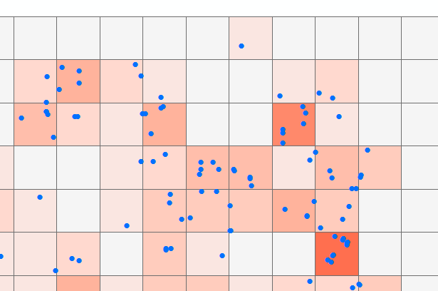
生成后的效果如下图:
ArcEngine 创建要素,删除要素,生成网格,渲染图层(VB)的更多相关文章
- Arcgis engine 指定图层对要素进行创建、删除等操作
Arcgis engine 指定图层创建点要素 在指定的图层上创建一个点要素,点要素的位置是通过X,Y坐标指定的,下面是具体的注释 .其中 和IFeatureClassWrite接口有关的代码不要好像 ...
- ArcEngine查询、添加、删除要素的方法
原文 ArcEngine查询.添加.删除要素的方法 1.查找数据 1).利用FeaturCursor进行空间查询 //空间查询 ISpatialFilter spatialFilter = new S ...
- Geodatabase - 删除要素
//删除要素类. //例如:workspacePath=@"G:\doc\gis\1.400\data\pdb.mdb", featureClassPath="res2_ ...
- 如何删除要素类 IFeatureWorkspace 接口介绍(1)
如何删除要素类 要想删除一个要素类,那么必须先得到这个,在得到这个要素类的时候,我们要学习一个新的接口IFeatureWorkspace. IFeatureWorkspace 接口介绍 这个接口主要 ...
- openlayers2地图控件扩展:要素删除DeleteFeature
实现要素删除控件,扩展OpenLayers.Control类,实现效果:选择DeleteFeature工具后,选择要素,按delete键删除要素(这里的删除只是将feature设置成delete状态, ...
- ArcGIS Engine中删除要素的几种方法总结
转自原文 ArcGIS Engine中删除要素的几种方法总结 /// <summary> /// 通过IFeature.Delete方法删除要素 /// </summary> ...
- Three.js开发指南---创建,加载高级网格和几何体(第八章)
本章的主要内容: 一, 通过Three.js自带的功能来组合和合并已有的几何体,创建出新的几何体 二, 从外部资源中加载网格和几何体 1 前面的章节中,我们学习到,一个几何体创建的网格,想使用多个材质 ...
- 基于ArcGIS ModelBuilder的GDB批量分区裁剪——可保留原始GDB要素集要素类结构
文章版权由作者pxtgis和博客园共有,若转载请于明显处标明出处:http://www.cnblogs.com/pxtgis/. 一.概述 在数据处理工作中经常遇到批量裁剪ArcGIS文件地理数据库( ...
- 各种隐藏 WebShell、创建、删除畸形目录、特殊文件名、黑帽SEO作弊(转自核大大)
其实这个问题,经常有朋友问我,我也都帮大家解决了…… 但是现在这些现象越来越严重,而且手法毒辣.隐蔽.变态,清除了又来了,删掉了又恢复了,最后直接找不到文件了,但是访问网站还在,急的各大管理员.站长抓 ...
随机推荐
- vue用法父组件调用子组件方法--->$refs
vue下载excel模板(放入弹框独立出来)后再导入表格 子组件 <el-dialog title="导入" :visible.sync="dialogVisibl ...
- jekyll 添加 Valine 评论
本文告诉大家如何在自己搭建的静态博客添加 Valine 评论.在这前,我基本都是使用 多说,但是多说gg啦,所以就在找一个可以替换的评论 本来 Disqus是很好的,但是在国内很难打开,所以我就需要一 ...
- java异常处理格式
异常处理的5个关键字 try ,catch, finally throw, throws 我的总结: 捕获异常:先捕获小异常再捕获大异常. 程序是调出来的,不是写出来的:多测试是程序员的必修课. ...
- Bishops Alliance—— 最大上升子序列
原题链接:http://codeforces.com/gym/101147/problem/F 题意:n*n的棋盘,给m个主教的坐标及其私有距离p,以及常数C,求位于同一对角线上满足条件:dist(i ...
- ssh使用笔记
在集群管理和配置中有很多命令要在各个节点中发送(特别是Master->Worker),大家都不希望发送每一个命令时都输入一次密码,因此常常先配置实现Master无密码登录到所有的Worker节点 ...
- P1035 台阶问题二
题目描述 有 \(N\) 级的台阶,你一开始在底部,每次可以向上迈最多 \(K\) 级台阶(最少 \(1\) 级),问到达第 \(N\) 级台阶有多少种不同方式. 输入格式 两个正整数 \(N, K( ...
- 将url传参的中文字符在页面中显示正常
//将url传参的中文字符在页面中显示正常var url=decodeURI(url);
- ASP.NET Core 开启后台任务
本文告诉大家如何通过 Microsoft.Extensions.Hosting.BackgroundService 开启后台任务 实现 BackManagerService 类继承 Backgroun ...
- Spring Security 学习笔记-securityContext过滤器
位于过滤器顶端,第一个起作用的过滤器.SecurityContextPersistenceFilter 在执行其他过滤器之前,率先判断用户的session中是否已经存在一个SecurityContex ...
- 基于JWT的Token登录认证(一)
1.JWT简介 JSON Web Token(缩写 JWT),是目前最流行的跨域认证解决方案. session登录认证方案:用户从客户端传递用户名.密码等信息,服务端认证后将信息存储在session中 ...